Avalanche Bulletin
更新日時: 2024/03/24 05:30
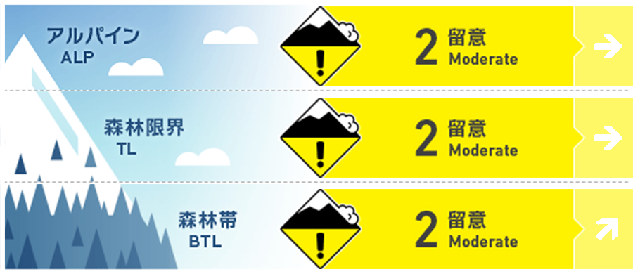
Hakuba
Alpine Low Pay attention to solar radiation during the day
Treeline Low Keep in mind solar radiation and high temperatures during the day
Below Treeline Fair Be alert for solar radiation and high temperatures during the day.
信頼度:○ good □ Fair △ Low
Travel and Terrain Advice
Caution is needed in certain locations where the instability of yesterday's fresh snow remains. The higher the elevation, the weaker the influence of solar radiation, and the cooler the temperature, the longer it will take for the new snow to stabilize. Pay attention to convex and isolated terrains in such areas, which have characteristics that make the snow more unstable. Also, very high temperatures are forecast for today. Keep an eye out for snow changes due to solar radiation and rising temperatures. Be especially vigilant on very steep south-facing slopes at lower elevations. Have a good day.
Avalanche Problem
ストームスラブ Storm slab


点発生湿雪雪崩 Wet Loose snow


Rating is as of morning. Note rising temperatures during the day and the effects of solar radiation.
面発生湿雪雪崩 Wet slab
Rating is as of morning. Very steep slopes with Melt-Freeze crusts under fresh snow, be alert for reduced snow intensity due to high daytime temperatures.
持続型スラブ Persistent slab


概要
Avalanche
Yesterday (23rd), several avalanches of size 1-1.5 storm slabs were reported. Shooting cracks were also reported. These were caused by snow that fell during the day.
Snowpack
Yesterday, a low pressure system over the Sea of Japan passed over Hakuba during the day, and an easily understandable change in instability was observed. Strong snowfall began in the morning, and sluff flowed on steep slopes where there was rapid accumulation. Later, with higher temperatures and southwest winds, the new snow quickly took on the characteristics of a slab, and where the underlying layer was hard, such as crust, ski cuts easily caused avalanches. By mid-afternoon, as the low pressure system moved out of the area to the east, the wind direction shifted to the north, but the higher temperatures continued the sintering of the new snow, causing shooting cracks and other problems. Snowfall amounts in the upper below treeline ranged from 15-30 cm. Today, it is necessary to be aware of where this instability remains and to notice any changes in the snow due to the significant temperature increase during the day.
Weather
Today, high pressure is expected to prevail at first, but a front is expected to extend from Huanchu to the south coast of Honshu, which will be affected by moist air. The Japan Meteorological Agency is forecasting northerly winds, clear skies, cloudy skies before noon, and a daytime high of 17 °C for northern Nagano Prefecture. At 703 m elevation, the temperature is -2.5 °C (as of 5:00), and no new snow has fallen in the past 12 hours.