
Avalanche Bulletin
更新日時: 2024/03/23 06:00
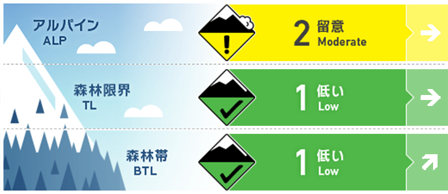
Myoko
Alpine Low
Treeline Low
Below Treeline Fair Note rising temperatures and onset of rainfall
信頼度:○ good □ Fair △ Low
Travel and Terrain Advice
In alpine areas, beware of unstable snow remaining on characteristic terrain that can easily induce avalanches. Characteristic terrain includes slopes that are isolated terrain or convex and unsupported. It is also important that there are no "terrain traps" below the slope. Slopes affected by yesterday's sunny slopes or elevated temperatures have formed crusts, making them difficult to ski. Falls can cause not only injuries, but also damage to equipment and other problems, so please ski at a controlled speed. Above, southwesterly winds are already coming in and temperatures are starting to rise. Weather conditions are expected to worsen, so please plan your tours with this in mind.
Avalanche Problem
ウインドスラブ Wind slab


Watch for wind slabs remaining in isolated terrain to the north. Be especially vigilant in peculiar locations such as cliffs below, extreme convexity, etc.
全層雪崩 Glide slab


Significant temperature increases and rainfall are forecast for today. Please stay away from slopes that already have open glide cracks.
持続型スラブ Persistent slab


概要
Avalanche
Yesterday (22nd), a size 1 slab avalanche was reported during morning safety control at the ski resort. Also, during the day, a number of snowballs were observed due to wet snow caused by rising temperatures. No information has been received in the higher elevation mountain areas. In the neighboring Hakuba mountain range, several size 2-3.5 avalanches were observed in the alpine area, probably occurring within the past 24 hours.
Snowpack
The snow from the most recent storm event, which constitutes the snowpack surface layer, is settling. On the higher elevation, northern slopes, the low-density snow may not yet have gained sufficient strength. Therefore, we still need to be vigilant where wind slabs are on top of it. The persistent weak layer (caused by the rainfall on February 21), which had been a long-standing warning, is considered to have generally eliminated the problem near the treeline. For the alpine areas, information is lacking.
Weather
Today, low pressure is expected to move from the Sea of Japan to the Sanriku Coast. The Japan Meteorological Agency is forecasting winds from the south, later from the west, cloudy, morning to early afternoon, rain, and daytime high temperatures of 15 ºC (13 m elevation) for the Joetsu region of Niigata Prefecture. At Sasagamine, Myoko (elevation 1,310 m), the temperature is -1 °C (as of 4:45 a.m.), with no new snowfall in the past 12 hours.