Avalanche Bulletin
更新日時: 2024/03/23 05:30
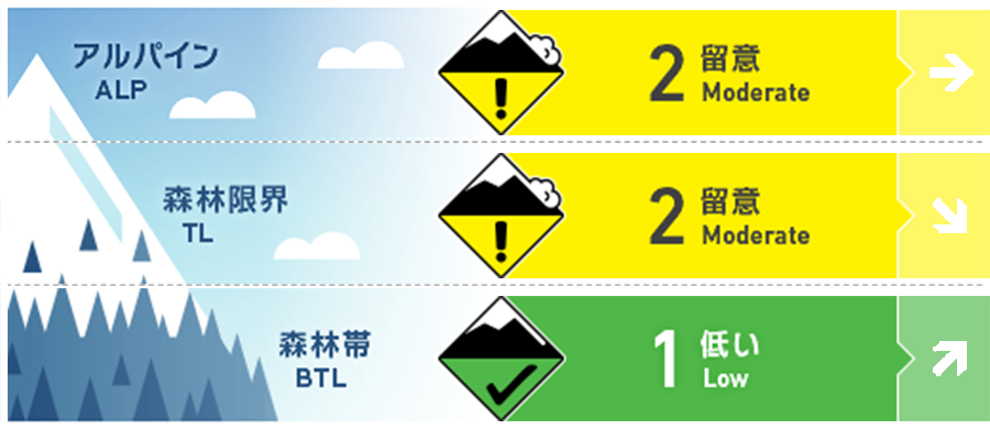
Hakuba
Alpine Low
Treeline Fair
Below Treeline Fair Note the onset of rainfall
信頼度:○ good □ Fair △ Low
Travel and Terrain Advice
At higher elevations, watch out for unstable snow remaining on characteristic terrains that can easily trigger avalanches. Characteristic terrain includes slopes that are isolated terrain or convex and unsupported. It is also important that there are no "terrain traps" below the slope. On yesterday's sunny slope, crusts have formed, making it difficult to ski. Falls can cause not only injuries but also damage to equipment and other problems, so please ski at a controlled speed. On the main ridge, southwest winds are already coming in and temperatures are starting to rise. Weather conditions are expected to worsen, so please plan your tours with this in mind.
Avalanche Problem
ウインドスラブ Wind slab


Note the remaining wind slab on isolated terrain to the north. Whumpfing sounds have been reported where distinctive slabs are placed. Be especially vigilant at peculiar locations such as cliffs below, extreme convexity, etc.
ストームスラブ Storm slab


On an extremely steep slope, unaffected by wind.
持続型スラブ Persistent slab


概要
Avalanche
Yesterday (22nd), as the weather improved, several avalanches of size 2-3.5 were observed in alpine areas that were likely to have occurred within the past 24 hours. These included Hakuba Daisekkei, Karamatsu-dake Kaerazu-no-ken II, Shiratake, Nishi-toumiyama, and Happo-one.
Snowpack
The snow from the most recent stormy weather, which constitutes the upper snowpack layer, is progressively settling. It was observed yesterday that on the higher elevation, northern slopes, the low-density snow (low pressure on the 20th) has not yet gained sufficient strength. Therefore, we still need to be vigilant where wind slabs are on top of it. Also, slightly deeper than that, to the north near the treeline, there are areas where faceting snow has formed on top of the Melt-Freeze layer formed by previous rainfall, which also has not yet fully intensified. The persistent weak layer (caused by the February 21 rainfall), which had long been a warning sign, is considered to have largely eliminated the problem near the treeline. For the alpine areas, information is lacking.
Weather
Today, the area is expected to be affected by low pressure and moist air moving from the Sea of Japan to the east of Japan. The Japan Meteorological Agency is forecasting southerly winds, cloudy skies, morning to early afternoon, rain or snow, and daytime highs of 11 °C for northern Nagano Prefecture. At 703 m elevation, the temperature is -2.8 °C (as of 5:00 a.m.), with no new snowfall in the past 12 hours.