Avalanche Bulletin
更新日時: 2024/03/22 05:30
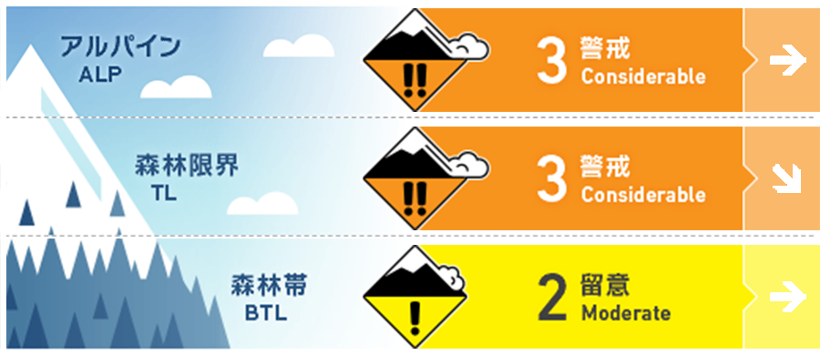
Hakuba
Alpine Low
Treeline Low
Below Treeline Fair
信頼度:○ good □ Fair △ Low
Travel and Terrain Advice
The higher the elevation and the windier the slope, the greater the risk of snow from this storm. In larger terrains, conditions are still such that avalanches of any size are possible. If you are in that terrain, is there a safe place to regroup? This is a very important perspective to consider. The weather is improving, but it's a good idea to hold your elation and start the day with conservative decision-making on smaller slopes, checking out the snow conditions. If the wind doesn't affect the slope and it is a simple slope, you will enjoy good fresh snow, which is hard to believe it is March. When doing so, pay maximum attention to the slope's incline. If the snow is good, you should be able to enjoy it even if the slope is a little slower. And it is the most effective option for avalanche safety. At lower elevations, the snowpack was very thin. Don't forget that this snowfall could be hiding holes and glide cracks in the stream bottom. Have a good day.
Avalanche Problem
ウインドスラブ Wind slab


On the main ridge, winds are averaging 15 m/s or higher, with winds prevailing from the northwest yesterday and from the west since last night. Be alert for slabs forming in easily triggered areas, such as isolated terrains and convexities.
ストームスラブ Storm slab


On very steep slopes where wind slabs have not formed, the danger of storm slab continues. On terrain where the terrain is not shaped to support snow accumulation, for example, avalanches can still be triggered by human stimulus.
持続型スラブ Persistent slab


A persistent weak layer is buried in the middle layer of snow cover.
概要
Avalanche
Yesterday (21st), a size 1 avalanche was reported in the morning control of the ski area. Several size 1-1.5 storm slab avalanches were also reported below treeline. Whumpfing sounds and shooters were also reported, albeit limited.
Snowpack
Stormy snow (50-70 cm) was reported to be settling rapidly yesterday at lower elevations. This is due to the sunshine that came in yesterday at lower elevations. On the other hand, strong northwest to west winds continue to blow at higher elevations. Cold air is moving in and temperatures continue to be as low as -10°C at elevations near 1,500 m. At higher elevations, it is necessary to act on the assumption that the instability of stormy snow has not yet been fully resolved.
Weather
Today, the area will be covered by high pressure, but is expected to be affected by a trough and cold air. The Japan Meteorological Agency is forecasting northerly winds, cloudy, sometimes sunny, and a daytime high of 6 °C for northern Nagano Prefecture. At 703 m elevation, the temperature is -4.1 °C (as of 5:00 a.m.), and no new snow has fallen in the past 12 hours.