Avalanche Bulletin
更新日時: 2024/03/14 05:30
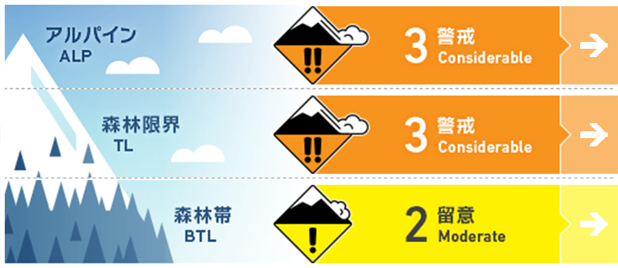
Hakuba
Alpine Low Note the effect of solar radiation
Treeline Low Note the effects of elevated temperature and solar radiation
Below Treeline Fair Watch for rising temperatures and solar radiation effects.
信頼度:○ good □ Fair △ Low
Travel and Terrain Advice
At this time (5:00 AM) it is snowing weakly, but the weather is forecast to improve later in the day. When visibility improves, look for avalanche activities. This is the most important information to judge the conditions. Also, observe the snow surface for signs of strong winds or if the upper snowpack has a tendency to slab. Assuming that the instability of storm weather has not yet been eliminated, choose a slope with a high degree of safety. The risk can be greatly reduced by choosing slopes that are low angles, and by choosing smaller slopes that support the snowpack rather than larger terrains. It is very important to act on principle, skiing one person at a time and watching your fellow skiers in a safe place. The weather forecast is predicting southerly winds and a large temperature increase. Keep an eye out for snow changes during the day. Have a good day.
Avalanche Problem
ウインドスラブ Wind slab


The wind on the main ridge is shifting from north to west, averaging about 10 m/s. Watch out for slabs on the side faces of the tributary ridges that form as the wind turns around. Remember that even hard wind slabs that form at higher elevations may become less intense and easier to trigger due to daytime warming and strong solar radiation.
ストームスラブ Storm slab


Terrain selection should be based on the assumption that the instability of rough weather has not yet been resolved.
持続型スラブ Persistent slab


The danger of persistent slabs from ice layer or Melt-Freeze crusts formed by the February 21 rainfall and faceted snow that formed on top of them has not yet been completely eliminated.
概要
Avalanche
Yesterday (13th), numerous size 1-1.5 avalanches were reported at the ski area safety control. On the south face, they originated from crust surfaces formed by solar radiation on the 11th. No information has been received in the higher elevation mountain areas, so please observe carefully and assess the situation.
Snowpack
On the 12th, a low pressure system passed through the area and shifted to a winter pressure pattern. In the early morning of yesterday (13th), the intensified pressure system brought about 30 cm of snowfall accompanied by extremely strong winds. As a result, many areas of "upside-down structure," where high-density snow was placed on top of relatively low-density snow, appeared, causing many avalanches. In the yesterday morning, the snow was sensitive where wind slabs had formed, and later, with solar radiation and rising temperatures, storm slabs responded even where the wind was weak.
Weather
The Japan Meteorological Agency is forecasting southerly winds, clear skies, occasional cloudiness, and a daytime high of 11 °C for northern Nagano. At 703 m elevation (Hakuba), the temperature is -5.8 °C (as of 5:00), with no new snowfall in the past 12 hours.