
Avalanche Bulletin
更新日時: 2024/03/12 06:00
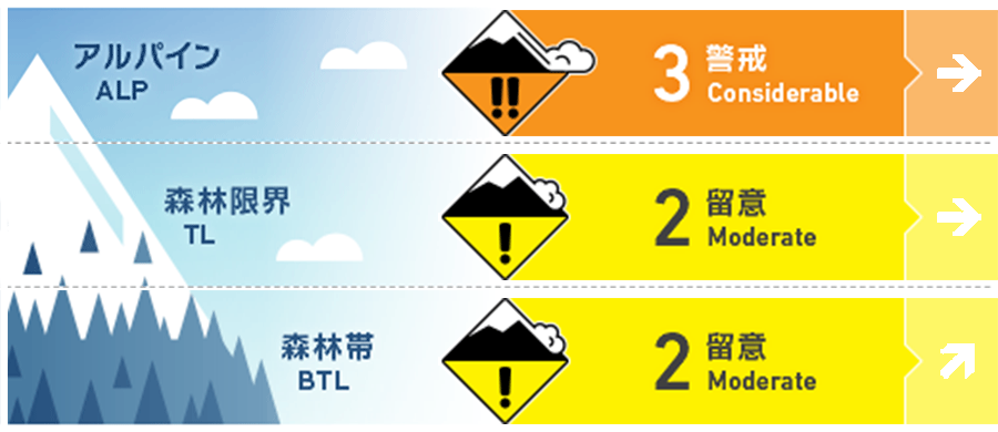
Niseko Yotei Yoichi Shiribeshi
Alpine Good Pockets of wind slab exist around ridgeline and in protected areas that have been cross loaded.
Treeline Good Wind slab can be found in protected areas on lee slopes.
Below Treeline Good
信頼度:○ good □ Fair △ Low
Travel and Terrain Advice
With the potential of settled weather in the coming days and periods of clear skies the urge to go futher in the backcountry will grow. We continue to manage variable conditions with firm condtions on windward westerly aspects and reactive wind slab at higher elevations on easterlies. An increase in temperatures at lower elevations will have created a melt-freeze crust. With variability comes the need to slow down and evaluate terrain as you change aspects or elevations. As temperatures fluctuate during the day the snowpack will change also resulting in the need for constant assessment until you are back at the trailhead and off snow.
Avalanche Problem
ウインドスラブ Wind slab


Recent wind events have re-distributed the latest new snow onto easterly aspects creating wind slab that has proven to be reactive. Look for signs of fresh wind load at upper elevations and avoid cross loaded features such as cornice rolls or terrain traps. Recent higher temperatures have made these slabs stiffen and become reactive to single person loads.
点発生湿雪雪崩 Wet Loose snow


Higher temperatures at lower elevations will heat the snow surface creating the possibility of wet loose activity. Look for signs so roller balling to suggest the snow surface is losing cohesion during the warmest part of the day.
概要
Avalanche
On the 11th of March a group backcountry users were caught in an avalanche on Mt Yotei resulting in injury. The slide was reported as a wind slab up to size 3 and occurred on a northerly aspect in the tree line. Also, on the 11th another person was caught in a wind slab avalanche on an easterly aspect of Mt Iwaonupuri causing injury. This slab was observed as a size 1.
Snowpack
We have received a light dusting of new snow across the region on Tuesday morning. Recent winds have transported the latest new snow onto lee slops where activity has been recorded across the region. A spike in temperatures on Monday resulted in heavy wet conditions at lower elevations and will likely have created a crust.
Weather
Light to moderate northerly winds will continue in the coming days increasing into Wednesday morning. We can expect snow flurries and periods of broken sunshine in the coming days. Temperatures will rise to above freezing at lower elevations.


