
Avalanche Bulletin
更新日時: 2024/03/12 06:00
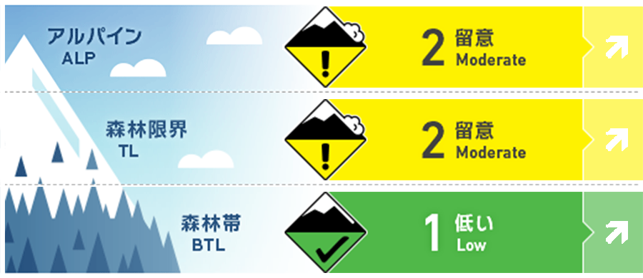
Myoko
Alpine Low Watch for more snowfall and wind.
Treeline Low Watch for more snowfall and wind.
Below Treeline Fair Watch for more snow or rainfall and wind.
信頼度:○ good □ Fair △ Low
Travel and Terrain Advice
Even though different types of avalanches exist in the mountains, the most important thing to do for safety is to understand the terrain and use it wisely. It is almost impossible to avalanche all slopes of a snow-covered mountain. There is always a safe place in the mountains with respect to avalanches. Whether you are experienced or inexperienced, avalanche terrain awareness remains paramount. With the speed of the approaching low-pressure system, the weather could deteriorate quickly in the coming days. Once rainfall begins, the danger level at lower elevations will increase significantly, so plan your activities with this in mind.
Avalanche Problem
ストームスラブ Storm slab


Stormy snow has not yet fully stabilized. Please be vigilant on isolated steep slopes.
ウインドスラブ Wind slab


With the approaching low pressure system, the wind direction has changed and strong southwest winds are beginning to blow overhead. Watch for slabs forming in different locations than yesterday.
持続型スラブ Persistent slab


On the southeast side near the treeline, it has been observed that the tenperature gradient has dissipated and is slowly rounding. However, caution is still needed.
概要
Avalanche
Yesterday (11th) was a beautiful day and multiple avalanches were observed. There were two types of avalanches observed, one being a storm slab or wind slab caused by the snow that fell on the 9th and 10th. The first was a storm slab or windslab caused by the snowfall of the 9th and 10th, size 1-2, both spontaneous and induced by skiers. The other type was a size 1-1.5 loose snow avalanche caused by snow drying out due to radiative cooling.
Snowpack
Yesterday, it was observed that the upper snowpack, under the influence of solar radiation and elevated temperatures, proceeded to sintering at lower elevations and on the southern slopes, settling in the afternoon. Crusts also formed on the snow surface at lower elevations. The snow on the north side remained dry. As for the weak layer of persistent slab, it is observed that near the treeline, the tenperature gradient has dissipated and is slowly rounding. However, in the same trend, a size 3 avalanche was also observed yesterday in the Hakuba Mountains area, requiring continued vigilance. There is great uncertainty.
Weather
Today, a low pressure system is expected to move east-northeast over the southern coast of Honshu while developing. The Japan Meteorological Agency is forecasting northerly winds, later, slightly stronger, cloudy, rain before noon, and daytime high temperatures of 8 ºC (13 m elevation) for the Joetsu region of Niigata Prefecture. At Sasagamine, Myoko (elevation 1,310 m), the temperature is -1 °C (as of 4:45 a.m.), with no new snowfall in the past 12 hours.