Avalanche Bulletin
更新日時: 2024/03/12 05:30
Hakuba
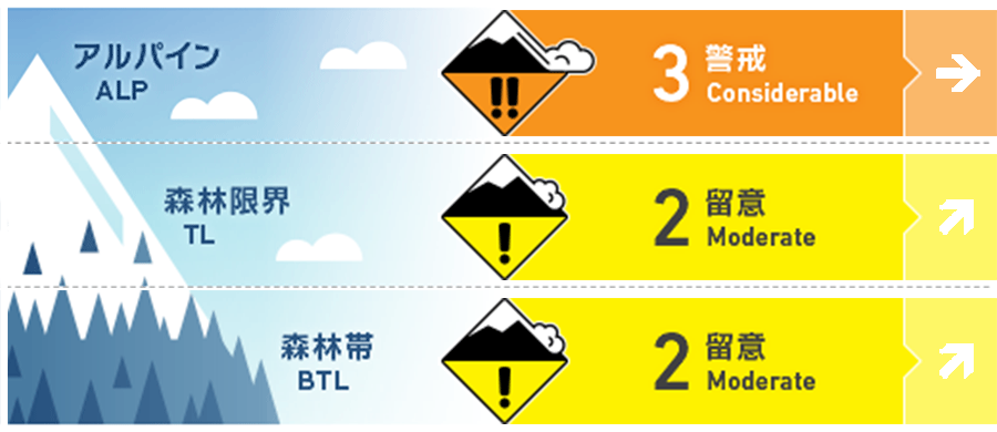
Alpine Low Watch for more snowfall and wind
Treeline Low Watch for more snowfall and wind
Below Treeline Fair Watch for more snowfall and wind
信頼度:○ good □ Fair △ Low
Travel and Terrain Advice
Even though different types of avalanches exist in the mountains, the most important thing to do for safety is to understand the terrain and use it wisely. It is almost impossible to avalanche all slopes of a snow-covered mountain. There is always a safe place in the mountains with respect to avalanches. Whether you are experienced or inexperienced, avalanche terrain awareness remains paramount. With the speed of the approaching low-pressure system, the weather could deteriorate rapidly. Strong southwesterly winds are already blowing above us, so please plan your activities taking these factors into account.
Avalanche Problem
ストームスラブ Storm slab


Stormy snow has not yet fully stabilized. Please be vigilant on isolated steep slopes.
ウインドスラブ Wind slab


With the approaching low pressure system, the wind direction has changed and strong southwest winds are beginning to blow on the main ridge. Watch out for slabs that are forming in different locations than yesterday.
持続型スラブ Persistent slab


Near the treeline, it has been observed that the tenperature gradient has dissipated and is slowly rounding. However, due to the thickness of the faceted snow layer, continued vigilance is required. There is great uncertainty.
概要
Avalanche
Yesterday (11th) was a beautiful day and numerous avalanches were observed. There were three types of avalanches observed, one being a storm slab or wind slab caused by the snow that fell on the 9th and 10th. These avalanches were caused by the snowfall of the 9th and 10th, with a size of 1-2.5, both spontaneous or triggered by skiers. The second was a size 1-1.5 dry loose snow avalanche caused by snow that had dried out due to radiative cooling. The last is a size 3 avalanche inferred to be a persistent slab.
Snowpack
It was observed that the upper snowpack, which had been showing active avalanche activity yesterday morning, proceeded to sintering at lower elevations and on the southern slopes due to the effects of elevation and rising temperatures, and settled in the afternoon. Crusts formed on the snow surface at lower elevations than around 2,000 m elevation. Snow on the northern side remained dry. The avalanche observed yesterday on the east-southeast slope of Happo-One at an elevation of around 2,300 m had a fracture line at least 300 m wide. No field survey has been conducted, but based on previous snowpack observations and fracture line data from nearby persistent slab avalanches, we suspect that the avalanche must be a persistent slab.
Weather
Today, a low pressure system is expected to pass near the Izu Islands and move to the east of Kanto in the evening. The Japan Meteorological Agency is forecasting southerly and northerly winds, snow or rain, and daytime high temperatures of 6 °C for northern Nagano Prefecture. At 703 m elevation in Hakuba, the temperature is -0.6 °C (as of 5:00 a.m.), and no new snow has fallen in the past 12 hours. The Nagano Prefectural Meteorological Office has forecast 30 cm of snowfall for northern Nagano Prefecture at 4:42 a.m. on March 12 in the 24-hour period ending at 6:00 a.m. on March 13.