Avalanche Bulletin
更新日時: 2024/03/07 05:30
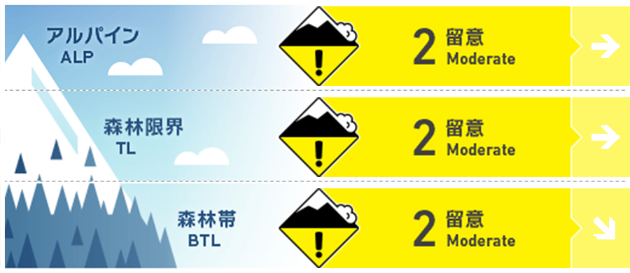
Hakuba
Alpine Low
Treeline Fair
Below Treeline Fair
信頼度:○ good □ Fair △ Low
Travel and Terrain Advice
Be alert for wind slabs at higher elevations. The instability of stormy weather has not yet been resolved, so watch out for storm slabs in isolated terrains and other areas where the snow surface layer has strong slab characteristics. As temperatures have dropped, dry snow can be enjoyed on the north-side slopes that are not affected by the wind. At the same time, however, terrain selection is key, as there are still areas on the north side where the snowpack is unstable. Avoid slopes where the terrain is not shaped to support snowpack and look for simple terrains with lower angle slopes. Also, be sure to check for "terrain traps" below that slope. When filming your fellow riders, choose a safe location off the avalanche terrain.
Avalanche Problem
ウインドスラブ Wind slab


The winds were light on the main ridge until yesterday afternoon. Since then, northwest winds have been increasing (averaging over 10 m/s). As you travel along, look for wind traces and notice the formation of wind slabs.
ストームスラブ Storm slab


Temperatures are dropping at higher elevations along with the winds that picked up yesterday afternoon. It is necessary to travel on the assumption that stormy weather instability remains in the north, where it can still be induced.
持続型スラブ Persistent slab


It has been observed that near the treeline, the temperature gradient has already dissipated. However, various tests have shown some cautionary results.
概要
Avalanche
Yesterday (6th), a size 1 storm slab avalanche was observed near the treeline. Similar avalanches have also been reported in ski area safety control. During the day, a size 1 loose snow avalanche of size 1 wet avalanche was reported at lower elevations, due in part to elevated temperatures.
Snowpack
As of yesterday, 30-40 cm of recent new snow had accumulated under light wind conditions. Within this layer of new snow, there were areas that had not yet sintered sufficiently, so avalanches were occurring in terrain pockets where the new snow had strong slab characteristics. On top of this is a slab caused by snow that was moved by winds that strengthened yesterday afternoon. A persistent weak layer has formed in the middle snowpack on some of the northern slopes of the treeline and alpine, and remains a cause for concern. At lower elevations, the snow had turned into moist conditions, caused by yesterday's high temperature.
Weather
Today, high pressure over the Sea of Japan is expected to prevail, but the area will be affected by a pressure trough and moist air. The Japan Meteorological Agency is forecasting northerly winds, cloudy with occasional sunshine, and a daytime high of 6 ºC for northern Nagano Prefecture. At 703 m elevation in Hakuba, the temperature is -2.2 °C (as of 5:00 a.m.).