
Avalanche Bulletin
更新日時: 2024/03/02 04:00
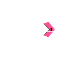
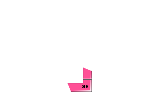
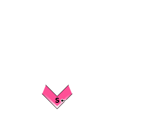
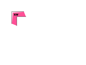
Kagura Tanigawa Hotaka
Alpine Low Snowfall and wind effects unknown
Treeline Fair Watch for increased snowfall and wind effects in the future.
Below Treeline Fair Watch for increased snowfall and wind effects in the future.
信頼度:○ good □ Fair △ Low
Travel and Terrain Advice
Dangerous avalanche conditions. Beware of triggering storm slabs at variable slopes and on open steep slopes with few trees. We recommend that you act at a reduced slope. Be aware of the presence of start zones overhead even if you yourself are at a slower slope. The low snowpack exposes "terrain traps" such as deep streams, cliffs, rocks, and standing timber that can increase damage even if the size of the avalanche that occurs is small. Care should also be taken to avoid falling into gully.
Avalanche Problem
ストームスラブ Storm slab


Beware of steep slopes
概要
Avalanche
Yesterday (1st), there was a report of multiple human-triggered slab avalanche size 1-1.5 observed on steep slopes around 1500m to 1400m.
Snowpack
Crusts have formed on the steep southerly slopes and in all directions below about 1,700 m due to the effects of solar radiation and elevated temperatures on the 29th, and snowfall from the 29th is on top of these crusts by 30-40 cm or more. Low-density snowfall has been observed on the boundary surface, from which human-triggered avalanches have been reported, so caution should be exercised in bonding.
Weather
As of 4:00 pm, the temperature at Amedas Fujiwara is -4.3°C. 8 cm of snow has fallen in the past 8 hours, and snowfall is still continuing in the surrounding areas. The Japan Meteorological Agency is forecasting cloudy skies at the foot of the mountains in northern Gunma Prefecture with occasional sunshine before noon and snow showers until early afternoon due to a low pressure pattern high in the west and low in the east and influenced by cold air.