Avalanche Bulletin
更新日時: 2024/02/29 05:30
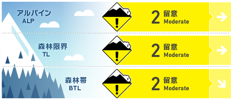
Hakuba
Alpine Low
Treeline Low
Below Treeline Fair
信頼度:○ good □ Fair △ Low
Travel and Terrain Advice
This is a day for careful terrain selection, as certain terrain still has instability in the snowpack that can cause avalanches at the provocation of a person. It is a good idea to check conditions on smaller slopes before jumping into larger ones. Whatever type of instability is present, the most effective safety measure is to reduce the slope angle. Look for simple terrain, avoiding areas with convex or isolated terrain where the snowpack is unlikely to support the terrain. It is also important to avoid "terrain traps" below you. Use safe terrain and continue to manage your group wisely. This will minimize damage in the event of an accident. Have a good day.
Avalanche Problem
ウインドスラブ Wind slab


Winds on the main ridge have also weakened to an average of 10 m/s since yesterday afternoon (28th). Watch out for wind slabs that have increased in hardness over time. Harder slabs will have fracture lines running above you when triggered. Also, remember that slabs on sunny slopes may be more prone to triggering as the slab hardness decreases.
ストームスラブ Storm slab


Note the very steep slopes where the terrain does not support snow accumulation.
概要
Avalanche
No new avalanches were reported yesterday (28th). However, whumpfing sounds and shooting cracks were reported on the east slope of the upper part of the below treeline.
Snowpack
In locations with average snowpack, the upper layer of snowpack is buried by the Melt-Freeze layer from the 21-day rainfall. In wind-effected areas, the Melt-Freeze layer is exposed and wind slabs have formed. At higher elevations, where there was no wind influence, the snow is less cohesive due to radiation. No significant vulnerability at the interface between the Melt-Freeze crust and the stormy snow above it has been reported as observed so far. However, avalanche triggering is a matter of balance between load and strength, so caution is still needed when larger loads are applied to extreme terrain.
Weather
Today, high pressure is expected to prevail at first, but low pressure is expected to move east-northeast over the southern coast of western Japan, bringing moist air. The Japan Meteorological Agency is forecasting northerly winds, clear skies, then cloudy, snow or rain at night, and daytime highs of 9 ºC for northern Nagano Prefecture. At 703 m elevation in Hakuba, the temperature is -5.1 °C (as of 5:00).