
Avalanche Bulletin
更新日時: 2024/02/25 06:00
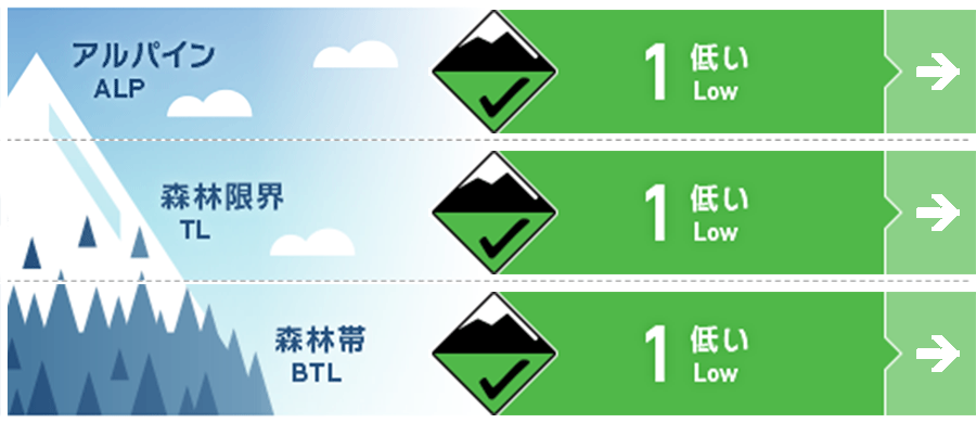
Myoko
Alpine Fair Note the start of snowfall
Treeline Fair Note the start of snowfall
Below Treeline Good Note the onset of rainfall or snowfall
信頼度:○ good □ Fair △ Low
Travel and Terrain Advice
In alpine areas, watch out for unstable snow remaining at terrain stations. Under a thin layer of new snow, icy surfaces are hidden, so be wary of slipping and falling. Please set your routes carefully to avoid going into steep slopes. The heavy rainfall on the 21st has caused the snow to melt in the lower elevations. Due to the lack of significant snowfall since then, some tour routes that are usually accessible may not be available this year. Please plan carefully.
Avalanche Problem
ウインドスラブ Wind slab


In Alpine, instability in the undo slab formed by yesterday's north-west winds may remain in terrain pockets. As of this morning, the wind direction at higher elevations has shifted to the southwest, but it is weak and does not appear to be having a significant impact. If wind speeds increase in the future, use caution.
概要
Avalanche
No new avalanches were reported yesterday (24th).
Snowpack
There is a hard, Melt-Freeze layer on the snow surface with about 15-20 cm of fresh snow on top of it. Yesterday, on the south face of the alpine area, the snow was affected by solar radiation, but on the north face it is well dry, partly due to radiation. With the drop in temperatures, the glide crack movement at lower elevations has also subsided.
Weather
The Japan Meteorological Agency is forecasting winds from the south, then from the north, cloudy, and from midday, rain or snow, with a daytime high of 8 °C (13 m elevation) for the Joetsu region of Niigata Prefecture. At Sasagamine, Myoko (elevation 1,310 m), the temperature is -5 °C (as of 4:45 a.m.), with no new snowfall in the past 12 hours.