Avalanche Bulletin
更新日時: 2024/01/28 05:30
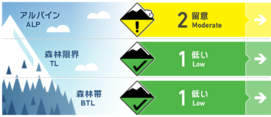
Hakuba
Alpine Fair Note the start of snowfall
Treeline Fair Note the start of snowfall
Below Treeline Fair
信頼度:○ good □ Fair △ Low
Travel and Terrain Advice
The avalanche cycle that began on the evening of January 23 appears to be over. Watch for unstable snow remaining in terrain pockets at higher elevations. Watch for slabs that have formed where the snowpack is likely to be unstable, such as isolated terrain of extreme shape. Also, remember to check for terrain traps below them. The snowpack at lower elevations is thin and the gully is not fully filled. Be alert for other hazards besides avalanches. Wise terrain use and the habituation of a principled course of action will reduce the number of accidents. Radiative cooling is cooling the snow well. Have a good day.
Avalanche Problem
ウインドスラブ Wind slab


Beware of unstable slabs remaining in extreme terrain pockets.
概要
Avalanche
Several size 1 loose snow avalanches were reported yesterday (27th). All were caused by ski cuts.
Snowpack
The snow from previous storms is settling; no problems have been found at this time on the boundary surface of the Melt-Freeze crust that was buried on the 23rd.
Weather
Today, the winter pressure pattern will gradually loosen, but cold and moist air is expected to affect some areas. The Japan Meteorological Agency is forecasting northerly winds, cloudy skies, snow or rain in the evening and at one time, and daytime highs of 4°C (39°F) for northern Nagano Prefecture. At 703 m elevation (Hakuba), the temperature is -10.6 °C (as of 5:00 pm), with no new snowfall in the past 12 hours.