Avalanche Bulletin
更新日時: 2024/01/27 05:30
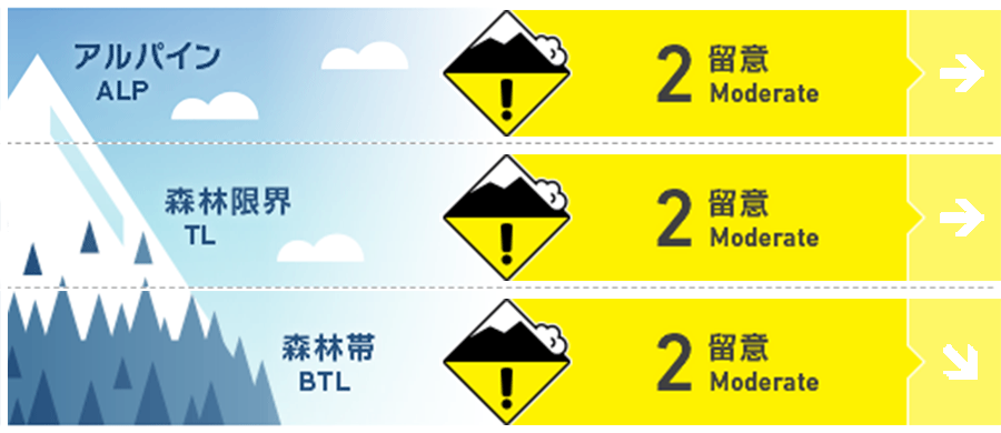
Hakuba
Alpine Fair Watch for wind slabs in terrain pockets.
Treeline Fair
Below Treeline Good
信頼度:○ good □ Fair △ Low
Travel and Terrain Advice
The snow itself from the heavy snowfall is stabilizing, but the strong winds that followed have moved the snow violently, creating hard slabs on the upper snowpack. The hard slabs that have formed on the steep slopes are then reduced in strength when exposed to strong solar radiation due to today's fine weather. It is a day with varying degrees of danger depending on time and location. Look for simple slopes where the wind is less of an influence and the terrain can easily support the snowpack. Don't forget to check for "terrain traps" below you. The mountain is expected to be crowded. Pay attention to the movements of other groups above and below you. Smart group management using the terrain will minimize accidents. Radiative cooling keeps the snow cold. If you choose the right slopes, you will enjoy great powder snow. Have a good day.
Avalanche Problem
ウインドスラブ Wind slab


Strong winds on the main ridge have already subsided, with an average wind speed of about 5 m/s over the past 12 hours. This means that at higher elevations there is a wind slab that has been time lapsed and hardened. Estimating the triggered sensitivity of hard slabs is difficult, and fracture lines often appear above you. Risk reduction is necessary using terrain.
ストームスラブ Storm slab


Note the isolated and extreme terrain geometry with no solar and wind effects
概要
Avalanche
Several size 1-1.5 slab avalanches were reported yesterday (26th) in the upper treeline. Avalanches are mostly occurring in the northern area of the Hakuba Valley.
Snowpack
The snow from the stormy weather (evening of the 23rd to evening of the 25th) is moving heavily with very strong winds (afternoon of the 25th to midday of the 26th), forming slabs. The winds are affecting lower elevations, even into the forests. On the ridges, hard Melt-Freeze layers are exposed, and on the leeward side there are wind slabs with increased hardness.
Weather
Today, the winter pressure pattern will gradually loosen, but cold and moist air is expected to influence the area. The Japan Meteorological Agency is forecasting northerly winds, clear skies, occasional cloudiness, snow in places, and daytime highs of 5 °C (41 °F) for northern Nagano Prefecture. At 703 m elevation, the temperature is -10.5 °C (as of 5:00), with no new snowfall in the past 12 hours.