
Avalanche Bulletin
更新日時: 2024/01/27 05:00
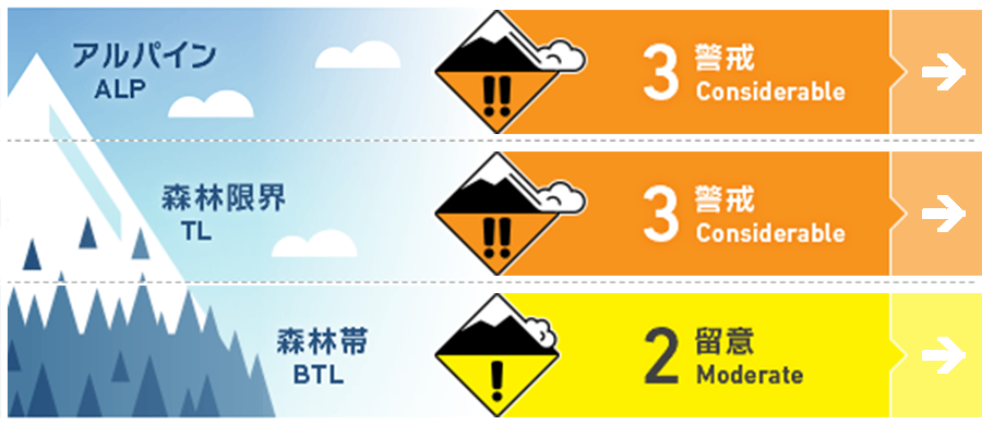
Kagura Tanigawa Hotaka
Alpine Low
Treeline Low
Below Treeline Fair
信頼度:○ good □ Fair △ Low
Travel and Terrain Advice
Due to snow movement caused by very strong winds from the west to northwest, wind slabs are forming on steep downwind slopes. Watch for bonding of freshly formed wind slabs. Watch for avalanches from large start zones overhead even if you are on a low slope yourself. There are exposed "terrain traps" such as deep gullies, cliffs, rocks, and standing timber that can increase damage even if the size of the avalanche generated is small. Please be careful of falling into gully and stepping over snow shelters. Snowfall is still continuing with strong winds. Avalanche danger increases with changes in snowfall amounts and winds. Please pay attention to weather changes.
Avalanche Problem
ウインドスラブ Wind slab


風下の稜線直下の急斜面に注意
概要
Avalanche
No new avalanche observed yesterday (26th), but limited information due to high winds and poor visibility
Snowpack
Due to the very strong west to northwest winds that have been blowing for the past two days and continue to this day, wind slabs are expected to form along the ridgeline and just below the ridge. Some areas of the ridge and open windy areas have been blown away and crusts are exposed.
Weather
As of 5:00, the temperature at AMeDAS Fujiwara is -1.7℃. About 5 cm of snow has fallen in the surrounding area and continues to be weak with strong winds. The Japan Meteorological Agency has forecast that the winter pressure pattern will gradually loosen, but the foothills of northern Gunma Prefecture will be affected by cold air and a pressure trough, so the forecast is for clear skies and occasionally cloudy skies.