Avalanche Bulletin
更新日時: 2024/01/25 05:30
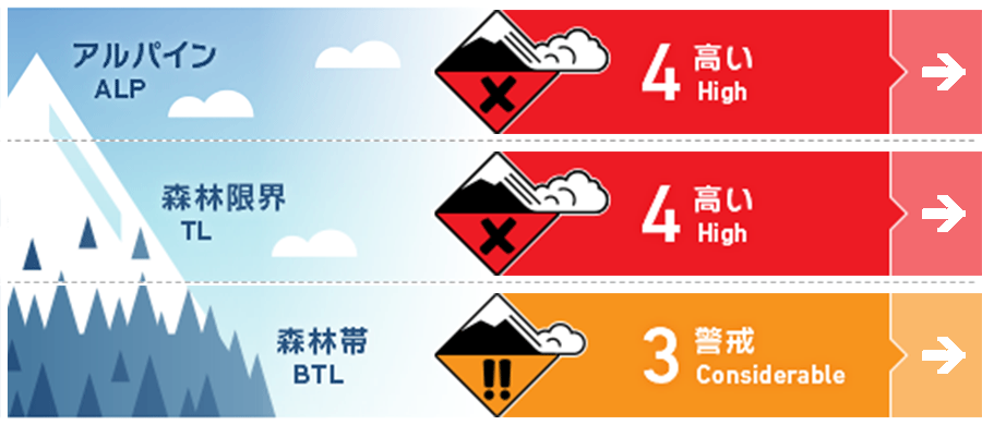
Hakuba
Alpine Fair
Treeline Fair
Below Treeline Fair
信頼度:○ good □ Fair △ Low
Travel and Terrain Advice
Avalanche danger remains high due to heavy snowfall. Strong cold air is moving in, and snow sintering and stabilization is progressing only slowly. Those entering the forest at lower elevations should carefully consider whether there are any large start zones above them. Also, there are many hazards at lower elevations that are hidden by this new snow, such as glide avalanche debris, glide cracks, and holes in stream bottoms. Always be on the lookout for what may be under the snow. Also, check for "terrain traps" below the slope, where even a small avalanche can have deadly consequences. Please act with a larger safety margin than usual. This is a good day for inexperienced groups to enjoy fresh snow in the ski area. Please stay out of the closed areas and enjoy safe skiing.
Avalanche Problem
ストームスラブ Storm slab


ウインドスラブ Wind slab


We need to consider not only what is forming on the surface, but also the possibility that a wind slab that formed some time ago may be hidden by subsequent snowfall. This situational awareness is difficult.
点発生乾雪雪崩 Dry Loose snow


On a very steep slope, unaffected by the wind.
概要
Avalanche
Yesterday (24th), a number of avalanches of size 1-1.5 storm slabs were observed in the ski area during safety control. Many of these are due to fragility within the fresh snow. In the mountain area, size 1 loose snow avalanches were reported. However, due to stormy weather, their reports are limited.
Snowpack
Snowfall, which began on the evening of the 23rd, has reached 50-70 cm in the upper Below Treeline, and is heaviest in the northern part of the Hakuba Valley. On the main ridge, winds are stronger than yesterday, averaging 20 m/s, with a maximum of 35 m/s, and temperatures have dropped to near -20 ºC. In the Below Treeline, bonding between new snow and old snow (Melt-Freeze crusts) was observed to be not so bad yesterday. However, we cannot rest assured that a hard snow surface will be a good bed surface. The bonding condition between new snow and old snow at higher elevations remains highly uncertain.
Weather
A strong winter pressure pattern is continuing. The Japan Meteorological Agency is forecasting northerly winds, cloudy skies, occasional snow, and daytime highs of 0°C for northern Nagano Prefecture. The Nagano District Meteorological Office is forecasting 30 cm of snowfall in 24 hours from 4:11 a.m. on the 25th to 6:00 a.m. on the 26th.