
Avalanche Bulletin
更新日時: 2024/01/23 05:00
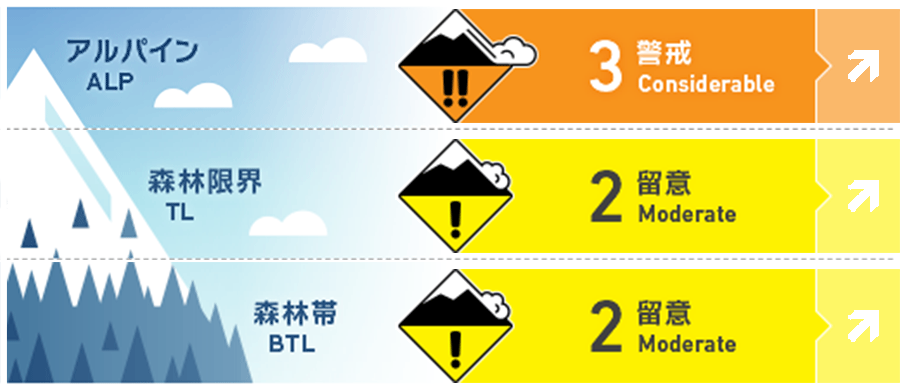
Niseko Yotei Yoichi Shiribeshi
Alpine Fair Increasing wind speeds and snow totals will see the avalanche hazard increase in the coming days.
Treeline Fair Increasing wind speeds and snow totals will see the avalanche hazard increase in the coming days.
Below Treeline Good Increasing wind speeds and snow totals will see the avalanche hazard increase in the coming days.
信頼度:○ good □ Fair △ Low
Travel and Terrain Advice
Strong winds and blowing snow will reduce visibility at upper elevations. Over the coming days it may be wise to stick to protected slopes at lower elevations and be cautious of specific terrain features above terrain traps. Look for test slopes to see how the latest new snow is bonding to the previous snow surface.
Avalanche Problem
ウインドスラブ Wind slab


Moderate to strong winds from the south east is likely to have re-distributed the latest new snow onto lee slopes. It is expected slab will have formed on exposed areas at upper elevations and may be reactive to single-person loads. Be wary of smooth wind pressed snow below ridgeline and look for fresh cornice development to suggest where the new snow has loaded.
ストームスラブ Storm slab


Increased snowfall in the coming days will promote the formation of storm slabs in sheltered areas at all elevations. Be wary of steep open sections on specific terrain features such as convex rolls even in the trees.
概要
Avalanche
On the 22nd cracking and size 1 avalanches (enough volume to knock a person from their feet) were observed at higher elevation in exposed terrain.
Snowpack
Continued snow fall over the last few days has brought up to 30cm of new snow across the region from the south. This new snow has fallen on a varied previous snow surface with a crust still being felt on solar aspects at lower elevations and a firm wind scoured surface found at upper elevations on the windward side. The lower snow pack appears well bonded.
Weather
Up to 10cm of new snow has fallen overnight into Tuesday morning with higher snow totals recorded in the south of the range. Wind speeds are expected to remain strong to gale at upper elevations from the south as a low-pressure system passes over Hokkaido inin the middle part of the week. Snowfall is expected to continue in the coming days.


