
Avalanche Bulletin
更新日時: 2024/01/02 06:30
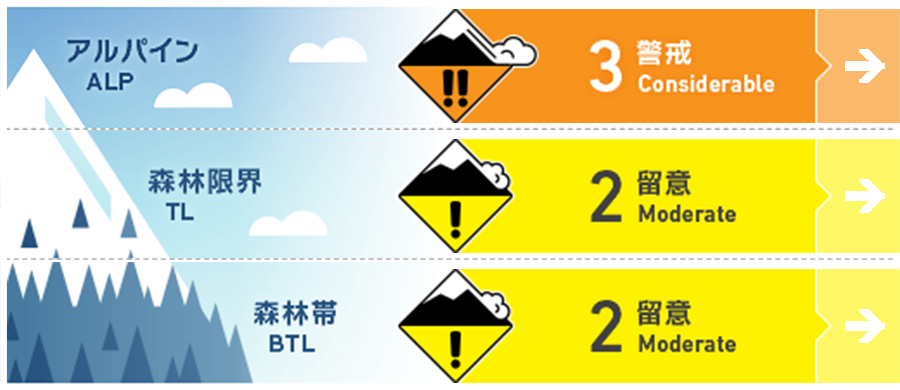
Niseko Yotei Yoichi Shiribeshi
Alpine Fair concerns of windslab still exists. Also remains the potential for instability in the new snow/old snow interface.
Treeline Fair Possibly of windslab at tree line especially in more open tree-line terrain and instability in new snow/old snow interface.
Below Treeline Fair Possible instability in new snow/old snow interface and loose surface snow running fast on steeper terrain sheltered from the wind.
信頼度:○ good □ Fair △ Low
Travel and Terrain Advice
Early season conditions still exist and snowpack stability needs evaluation. Caution is advised in all elevation bands. Terrain traps are still a big hazard and creek exits and steeper slopes in the tree-line should be met with caution. Take time and observe what you see and the hazards they might present.
Avalanche Problem
ウインドスラブ Wind slab


概要
Avalanche
Skier triggered avalanches in the Alpine and at Treeline reported recently. One person was injured in an avalanche incident on the southeastern slopes of Mt. Yotei yesterday.
Snowpack
Many areas in the forecasted zone have seen some amount of new snow in the last 48hrs with winds strong enough to transport the fresh snow and make a slab in the upper part of the snowpack. On polar aspects there has been reports of instability in new snow/old snow interface. There remains still a crust on solar aspects buried under the new snow. The depth of this solar crust varies depending on elevation and small changes in aspect.
Weather
Snowfall forecasted this evening and through the night giving way to clearer sky on Wednesday. Watch for warming temps today, but should cool back down to below freezing Wednesday. Winds are forecasted to be light with a mostly southernly flow today and switch to a light northerly flow Wednesday.


