
Avalanche Bulletin
更新日時: 2023/12/26 08:00
Niseko Yotei Yoichi Shiribeshi
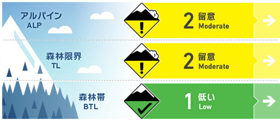
Alpine Fair Light to moderate winds in the alpine may have formed a windslab
Treeline Good Light to moderate winds in the treeline zone may have formed a windslab
Below Treeline Good The below treeline zone is still heavily covered by vegetation and has not reached threshold for avalanches except for in avalanche paths.
信頼度:○ good □ Fair △ Low
Travel and Terrain Advice
Lots of new snow over the past week is beginnning to settle. Monitor bonding within the storm snow. Early season conditions persist with lots of hazards lurking just below the surface snow. Travel with caution.
Avalanche Problem
ウインドスラブ Wind slab


点発生乾雪雪崩 Dry Loose snow


概要
Avalanche
No new avalanches reported
Snowpack
Approx 15cm H2D this morning in the Niseko area was accompanied by forecasted moderate - strong Westerly winds at TL overnight. 10mm SH (2023-12-25) reported in Shiribetsu area on steep and shady asp is now down approx 5mm. A thin sun crust formed yesterday on Steep S and E aspects. Hs ranging from 100-180cm at TL. Snowpack is generally right side up with ski quality reported to be excellent. Test profile on Dec. 24th at 1500m on SE asp of Yotei showed ECTP 15, 21 down 55cm at base of recent HST on density change.
Weather
The Westerly flow continues with an low approaching Tuesday afternoon. Light snow this morning will increase in intensity as the new system arrives with moderate snowfall expected this afternoon and overnight tonight. Winds will be light from the West today before shifting to moderate to strong NW tonight and tomorrow. Temps will remain cool and steady around -5C in the valley.


