Avalanche Bulletin
更新日時: 2022/12/30 05:30
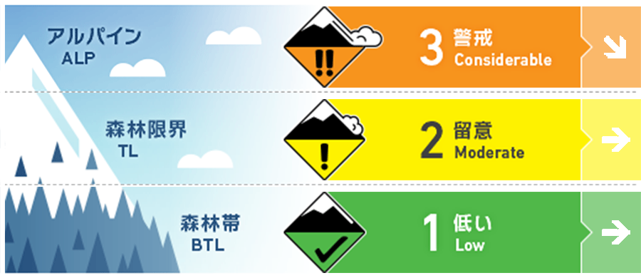
Hakuba
Alpine Low Looking for snow surface affected by wind.
Treeline Low
Below Treeline Fair
信頼度:○ good □ Fair △ Low
Travel and Terrain Advice
Dangerous conditions continue. Look for wind effects on the snowpack as you climb. Also, even small slopes can be extremely dangerous if there are terrain traps at the bottom of them. Please manage your group well by avoiding such areas and keeping your companions in view.
Avalanche Problem
ストームスラブ Storm slab


ウインドスラブ Wind slab


Pay attention to the traces that indicate the direction of the wind.
概要
Avalanche
Yesterday (29th), both size 1 slab and point release avalanches were observed. These avalanches were triggered by skiers.
Snowpack
Snowfall that began on the 28th brought new snowfall amounts of 30-40 cm near the treeline and 20 cm below treeline. The higher the elevation and the closer to the main ridge of the Northern Alps, the greater the snowfall. There is a weak layer inside the new snowpack that was accumulated without much wind influence, and this layer responded to skiers.
Weather
The Japan Meteorological Agency is forecasting that a winter pressure pattern will continue over northern Nagano Prefecture, with cloudy and sometimes sunny skies, some snowfall mainly along the mountains and in the Nakano Iiyama area, and a daytime maximum temperature of 4°C (41°F). At the foot of Mt. Hakuba (elevation 703m), the temperature is -0.7℃ (as of 5:00).