Avalanche Bulletin
更新日時: 2022/12/29 06:00
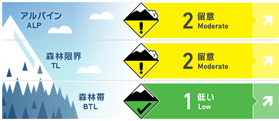
Hakuba
Alpine Low Pay attention to when the wind gets stronger and its direction.
Treeline Low Pay attention to when the wind gets stronger and its direction.
Below Treeline Fair
信頼度:○ good □ Fair △ Low
Travel and Terrain Advice
Those gaining elevation should be aware of the amount of new snow that has accumulated since last night. Snow is falling in light wind conditions, but please pay attention to changes in wind strength and direction. Freshly formed wind slabs are extremely fragile. Even a small avalanche combined with a "terrain trap" can have serious consequences. Also, remember that on south-facing slopes, rough, hard slopes may be hidden under that thin layer of fresh snow. This can cause unexpected falls & injuries.
Avalanche Problem
ストームスラブ Storm slab


As the amount of snow increases, the size of avalanches also increases.
概要
Avalanche
Yesterday (28th), a size 2.5 slab avalanche was observed on an isolated east-facing extreme terrain in the Alpine area.
Snowpack
The snowpack brought in by the previous storm had settled and suncrusts had formed on the surface of the snowpack that was affected by solar radiation. In places where it was blown away by the wind, strong winds blew it away and hard crusts underneath emerged. New snowfall began last night, with 10-30 cm on top of it.
Weather
The Japan Meteorological Agency is forecasting a winter pressure pattern for northern Nagano Prefecture, with the area being affected by a pressure trough and cold air, cloudy and sunny from morning to early afternoon, with some snowfall mainly along the mountains and in the Nakano Iiyama area, and a daytime maximum temperature of 6°C (46°F). At the foot of Mt. Hakuba (elevation 703m), the temperature is -0.7℃ (as of 5:00).