
Avalanche Bulletin
更新日時: 2022/03/02 04:23
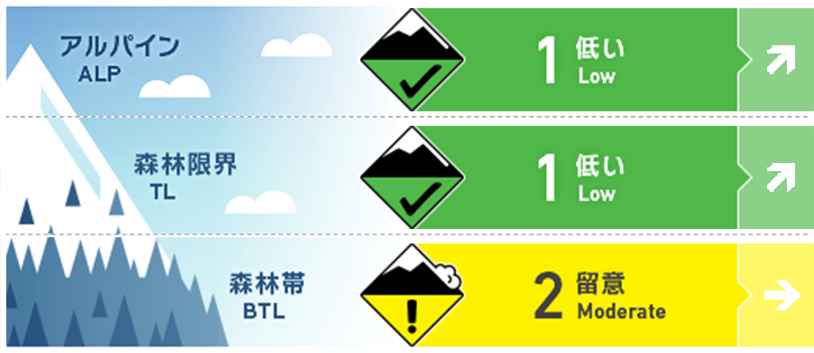
Kagura Tanigawa Hotaka
Alpine Low 昨夜からの風の影響に注意
Treeline Low 昨夜からの風の影響に注意
Below Treeline Fair 降雨と昇温の影響に注意
信頼度:○ good □ Fair △ Low
Travel and Terrain Advice
Pay attention to the presence of new wind slabs on the ridges at high elevations, on the steep slopes just below the supporting ridges. It is a forecast that the temperature will rise. Be aware of the possibility of wet snow-point generation avalanches from large south-facing steep slopes in the lower elevation zone that are susceptible to solar radiation, elevated temperatures, and rainfall, and Glide avalanche from open cracks or cliff-like slopes.
Avalanche Problem
点発生湿雪雪崩 Wet Loose snow


低い標高の大きな急斜面に注意
ウインドスラブ Wind slab


稜線、支尾根直下の急斜面に注意
概要
Avalanche
There were no reports of observing a new avalanche yesterday, but there were also few people entering the mountain.
Snowpack
On the southerly slopes, crusts were formed due to yesterday's solar radiation. In addition, the omnidirectional snow surface melted at an altitude of at least 1300 m or less due to the influence of rising temperatures. Snowfall that began at midnight is expected to be about 5-10 cm above it. This snowfall started raining at least 900m or less. There is a possibility that snow cover has shifted and wind slabs are formed due to the influence of the wind from last night at high elevations.
Weather
The temperature at AMeDAS Fujiwara as of 4:00 a.m. There was a snowfall of about 2 cm in the vicinity, and it continues even now. According to the Japan Meteorological Agency's announcement at 17:00, it will be covered by high pressure from the west, but due to the effects of cold and atmospheric pressure valleys, it will be cloudy in the northern part of Gunma prefecture and it will be sunny from before noon, and there will be snow or rain until dawn. .