
Avalanche Bulletin
更新日時: 2022/02/15 07:00
Niseko Yotei Yoichi Shiribeshi
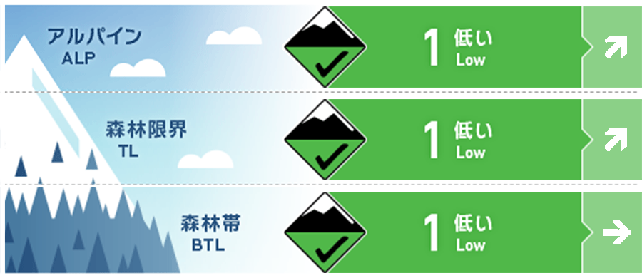
Alpine Good 急峻な地形で点発生乾雪雪崩がありえます。今晩から風が強まり、明日にかけてウインドスラブの形成が強く疑われます。Loose-dry activity can be found in steep terrain. Wind slab may begin to form as wind speeds increase late Tuesday into Wednesday morning.
Treeline Good 北側の急峻な地形では点発生乾雪雪崩がありえます。この状況は風が出始めると変わる可能性があります。On Northerly aspects, steep terrain will produce loose dry activity currently. This may change as wind speeds begin to increase.
Below Treeline Good 標高の低い場所ではグライドクラックが主な懸念事項です。Glide cracks remain a concern at lower elevations.
信頼度:○ good □ Fair △ Low
Travel and Terrain Advice
Depending on the degree of snowfall in the future, if the amount of snow that can be moved by the wind increases, wind slabs will form on the leeward side by Wednesday, and it will be necessary to be vigilant about it. Look for wind effects around the ridge on Wednesdays. The cornice that is just formed is brittle, so be careful about it as well. With plenty of snow available to transport the forecasted increase in wind speeds will begin to move snow onto the lee slopes by Wednesday morning resulting in a possible change in our avalanche hazard from loose dry to wind slab. Look for signs of wind-pressed snow on Wednesday especially around ridgelines. Cornice formation may alos grow and be brittle.
Avalanche Problem
点発生乾雪雪崩 Dry Loose snow


北側の斜面では、まだドライで乾いた雪があり、点発生雪崩がありえます。この雪崩は斜度が35°を超えると、その速度と量が増える傾向にあり、下方に地形の罠があれば、人を埋没させるに十分なものとなります。Across the Northerly aspects, loose dry activity remains a concern as cold snow can still be found. Above 35 degrees these avalanches can build in mass as they slide down the fall line and may have enough volume to bury a person if caught in a terrain trap.
概要
Avalanche
Over the past 48 hours, point avalanches have been observed in steep terrain facing north. If you observe something important in the field, you can email it directly to the Forecaster Team. Loose dry activity has been observed on steep Northerly aspects over the previous 48 hours . You can contact the forecasting team with any observation at forecasters@nadare.jp
Snowpack
This week has been cloudy, a little sunny, and a little snowfall. The overall trend of snow cover is stable, and the concern is only about the surface layer. It should be taken into account that surface frosts have been observed last weekend, and if this is buried, in the future, it will be a problem. The start of the week has produced broken clouds and sunny spells with little new snowfall . Overall snowpack remains strong with our only concern at present within the surface layers . Surface hoar was observed over the weekend which we will take into account for being Buried in the Future and Becoming a Weakness.
Weather
It is said that a low pressure will pass today (Tuesday), and southeastern winds will enter from evening to tomorrow. The overall amount of snowfall does not seem to be high, but there may be slightly stronger snowfall during the night. A lower pressure system will pass over the country throughout Tuesday bringing an increase in wind spreads from the South East late in the evening and into Wednesday morning. We can expect brief snow showers during the night although overall new snow totals will be LOW.


