
Avalanche Bulletin
更新日時: 2022/01/29 06:00
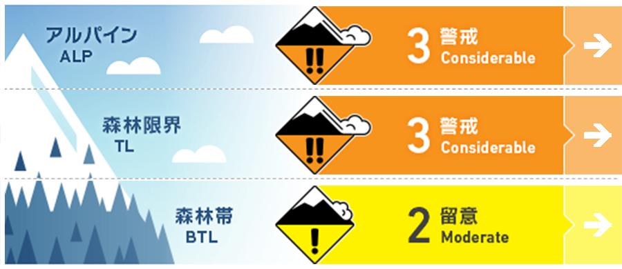
Myoko
Alpine Low 降雪量の多い山域の北側
Treeline Low 降雪量の多い山域の北側
Below Treeline Fair
信頼度:○ good □ Fair △ Low
Travel and Terrain Advice
Avalanche conditions are high in districts where there was a lot of snowfall since last night. Before entering a steep slope, be sure to thoroughly check the unstable elements that are in the snow cover layer. If the effect of the wind can be seen on the snow surface, reduce the slope and look for a slope without traps in the terrain. Snow is in good condition in areas where the wind is weak. Please do smart group management while communicating with your peers.
Avalanche Problem
ストームスラブ Storm slab


概要
Avalanche
Yesterday (28th), a large number of point occurrence avalanches, size 1 due to new snowfall, were observed in some areas where clouds were covered, such as the north side of the Myoko Mountains.
Snowpack
During the day yesterday (28th), point generation avalanches due to snow with weak binding force have been observed, and snow with low cohesion is buried by snowfall from last night. The amount of snowfall varies considerably in the mountainous area, and overall it is high on the north side. As you increase the elevation, you also need to consider redistribution due to wind effects.
Weather
The Japan Meteorological Agency predicts the west wind, rear, and northwest winds somewhat strong, snow, early afternoon, cloudy, and a maximum temperature of 4 degrees (elevation 13 m) for the Joetsu region of Niigata prefecture. At Myoko Sasagamine (elevation 1310m), the temperature is -7℃ (as of 5:00), and 3 cm snowfall has been observed in the past 12 hours.