
Avalanche Bulletin
更新日時: 2022/01/03 07:00
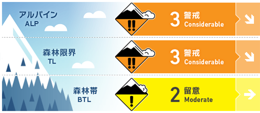
Myoko
Alpine Low
Treeline Low
Below Treeline Fair
信頼度:○ good □ Fair △ Low
Travel and Terrain Advice
Pay attention to the slab that formed from the snowfall from last evening. Particular attention should be paid to windslabs caused by winds from west to northwest at high elevations. Fresh snow heats up and rests on the snow surface, forming a hard, good (bad for us) sliding surface, hammered by the wind. Particular care should be taken on isolated terrain, such as convex. The snow cools down due to the cold and is in good condition, but don't forget to check if there is a “terrain trap” at the end of the slope before slipping in. Even small avalanches can be deadly. There has been a lot of snowfall, but the terrain has not yet been filled, and many early season hazards remain. Have a nice day while valuing basic group management.
Avalanche Problem
ウインドスラブ Wind slab


ストームスラブ Storm slab


概要
Avalanche
There were no reports of avalanches yesterday (1/2).
Snowpack
The series of heavy snowfalls since the end of the year have settling due to the good weather yesterday. Also, due to the impact of the storm of the day before yesterday, the snow surface has been subjected to severe degradation by the wind. This affects the lower elevation as if it were licking the surface of the mountain, and the snowfall from last evening is on top of this. This snowfall is generally deposited under the influence of northwestern winds.
Weather
The Japan Meteorological Agency predicts cloudy weather, morning and evening, snow or rain, and a maximum temperature of 6℃ (elevation 13m) for the Joetsu region of Niigata prefecture. At Myoko Sasagamine (elevation 1310m), the temperature was -6℃ (as of 6:00), and there was a snowfall of 17 cm in the past 12 hours. Looking at the entire Myoko Mountains, it has snowfall of 20-30 cm at an altitude of around 800 m.