
Avalanche Bulletin
更新日時: 2021/03/27 06:00
Niseko Yotei Yoichi Shiribeshi
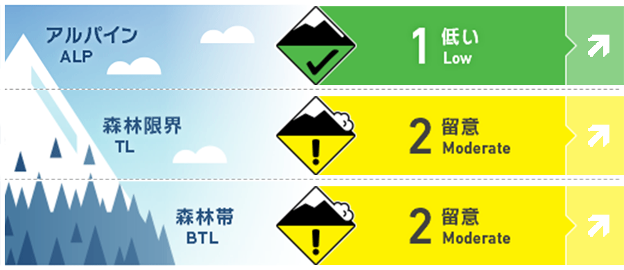
Alpine Fair As freezing levels rise over the weekend there is a possibility of wet loose activity at all elevations. 昇温の程度によって、すべての標高で濡れた雪の雪崩の危険が高まります。
Treeline Good Sunny days and warm temperatures will result in the snow surface losing cohesion and wet loose activity occurring in steep terrain. 昇温と日射の影響で雪面の雪の強度が落ちると、急斜面で濡れた雪の雪崩が発生しやすい状況となります。
Below Treeline Good At lower elevations, warm temperatures throughout the weekend will produce wet loose activity. 週末を通して高い気温が予報されており、継続して濡れた雪の雪崩への警戒が必要です。
信頼度:○ good □ Fair △ Low
Travel and Terrain Advice
As temperatures rise during the day look for any signs of roller balling off rock features in steep terrain as an indicator that the snow surface is becoming weak. At high elevations, exposed ridgelines may be wind stripped resulting in very firm conditions where crampons may be required. As the temperature rises, check whether snow balls are occurring in the vicinity of exposed rocks on steep slopes, and that the snow intensity on the snowy surface has decreased. At high altitudes, a hard thawed frozen layer is exposed in the vicinity of ridgelines hit by the wind, and there are places where it is impossible to act without crampons.
Avalanche Problem
全層雪崩 Glide slab


The timing of glide avalanches is very hard to predict. With warm temperatures and high freezing levels over the weekend, there is the possibility that meltwater will reach the base of the snowpack promoting these glide cracks to release. 全層雪崩の発生のタイミングを予測することは困難です。高温が予報されており、それによる融解水が積雪底部を融かし、全層雪崩の危険を高めます。
点発生湿雪雪崩 Wet Loose snow


At lower elevations, warm temperatures are promoting wet loose activity in steep terrain. With little in the way of an overnight freeze, the snow surface is becoming weak early in the day and natural wet point release avalanches are occurring. 低い標高帯では、高い気温によって濡れた雪の雪崩が高まります。夜間の気温低下も弱く、ほとんど凍結していないため、日中の早い時間帯で雪面の雪は強度を失い、濡れ雪の点発生雪崩が起こりうることを考えてください。
概要
Avalanche
Multiple wet loose avalanches up to size two have been reported across the region over the last week. Within the week until yesterday, multiple size 2 wet snow point generation avalanches have been observed and reported in the area where avalanche information has been announced.
Snowpack
The snowpack now resembles typical spring conditions. A melt-freeze cycle is well in effect with the snow surface becoming moist a losing cohesion in the heat of the day. It is a typical spring condition. It is a cycle in which the snow surface gets wet, loses strength and, again, freezes due to rising temperatures during the day.
Weather
Saturday and Sunday will see a high-pressure system sit over Hokkaido bringing warm temperatures and broken sunshine. Expect high freezing levels and the possibility of rain into the alpine late on Sunday. On weekends, there is a forecast for high pressure to rise over Hokkaido and the temperature will rise. Also, on Sunday afternoon, even at high altitudes, the temperature will be positive and rainfall forecast.