
Avalanche Bulletin
更新日時: 2024/03/30 04:00
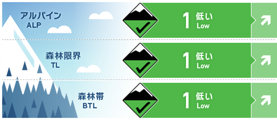
Kagura Tanigawa Hotaka
Alpine Low
Treeline Fair
Below Treeline Good
信頼度:○ good □ Fair △ Low
Travel and Terrain Advice
The spring cycle has begun. Avalanche danger levels vary from "low" to "high" depending on daytime temperatures and solar radiation. We recommend taking action before the crust loosens up due to the effects of solar radiation and warmer temperatures. Keep in mind the presence of wind slabs formed on extremely steep slopes just below the ridge and branch ridges at higher elevations, where the rain from yesterday's stormy weather has turned to snow. At lower elevations, watch for point-forming loose snow avalanches from large steep slopes and glide avalanches from glide cracks and cliff-like slopes. Do not enter the lower part of such areas or pass through them quickly.
Avalanche Problem
ウインドスラブ Wind slab


Be aware of extremely steep slopes just below the ridge and tributary ridges.
全層雪崩 Glide slab


Beware of open cracks and cliff-like slopes.
概要
Avalanche
昨日(29日)、観察者がいなかったため情報がない。
Snowpack
Snow accumulation is expected to be wet and then frozen, at least at elevations below 1,700 meters, due to the effects of rainfall up to yesterday. At higher elevations where it is turning to snow, wind slabs are expected to form on the downwind stream bottom under the influence of strong westerly winds. There are no reports of significant vulnerability observed in the middle to lower layers of the snowpack.
Weather
As of 4:00, the temperature at AMeDAS Fujiwara was 0.4°C. The JMA is forecasting generally clear skies and the possibility of continued yellow dust, with temperatures rising to 15°C at the foot of the mountain, due to high pressure.