
Avalanche Bulletin
更新日時: 2024/03/05 06:00
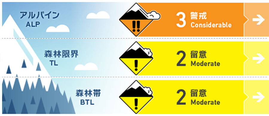
Myoko
Alpine Low
Treeline Low
Below Treeline Fair
信頼度:○ good □ Fair △ Low
Travel and Terrain Advice
Difficult avalanche conditions. Unlike yesterday, a day when avalanches can easily occur, this day is prone to errors in situational awareness. To the feel of walking, the snowpack may seem to be stabilizing. However, stormy snow is not yet fully sintering and the condition of the old snow surface is various, so the triggering sensitivity varies considerably from place to place. In addition, there are persistent slabs lurking to the north that are very difficult to deal with. What you can do to be safe is to be sensitive to avalanche terrain awareness and use low angles, simple terrain when skiing. Don't forget to check for "terrain traps" below you. The next stormy weather cycle will begin in the afternoon. Heavy snow is in the forecast, so please plan your tours with that in mind.
Avalanche Problem
ストームスラブ Storm slab


Be vigilant where fresh snow on the surface has more of a slab character.
ウインドスラブ Wind slab


Westerly winds are blowing above. Watch for changes in wind direction in the future.
持続型スラブ Persistent slab


Persistent slabs are induced where the snow cover is thin to the weak layer. A hard snow surface does not mean safety.
概要
Avalanche
Numerous size 1-1.5 storm slab avalanches were observed yesterday (4th) at the ski area safety control. Numerous loose snow avalanches were also observed. No reports have been received in the mountain areas due to poor visibility.
Snowpack
Snowfall since the afternoon of the 3rd has been 30-50 cm in the upper part of the below treeline, deposited by strong westerly winds. As of yesterday morning, this new snow was not coherent enough to cause a loose snow avalanche. Later in the afternoon, temperatures warmed up and the new snow was settling rapidly. In the middle layer of the snowpack, the Melt-Freeze layer (formed by rainfall on February 21) and faceted snow remain a concern.
Weather
The Japan Meteorological Agency is forecasting winds out of the south, then northeast, cloudy, rain or snow in the evening, and a daytime high of 9 °C (13 m elevation) for the Joetsu region of Niigata Prefecture. At Sasagamine, Myoko (elevation 1,310 m), the temperature is -9 °C (as of 4:45 a.m.), with no new snowfall in the past 12 hours.