
Avalanche Bulletin
更新日時: 2024/03/03 06:00
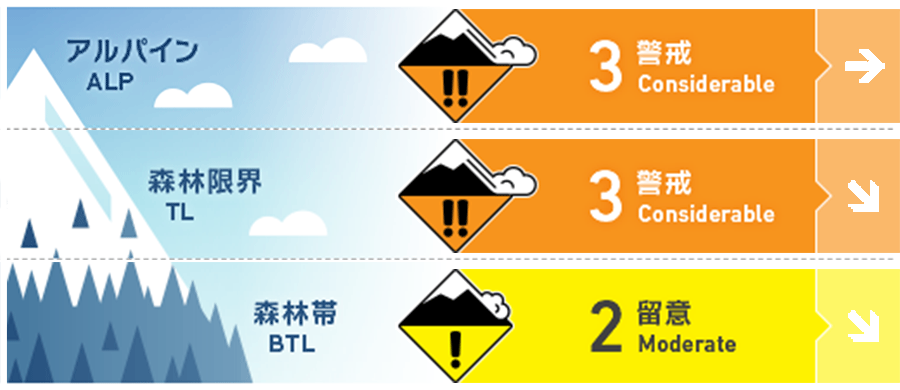
Myoko
Alpine Low
Treeline Low
Below Treeline Fair Keep in mind the rising temperature and solar radiation during the day
信頼度:○ good □ Fair △ Low
Travel and Terrain Advice
Compared to yesterday, the avalanche danger level is decreasing, but there is still enough instability in certain terrain for an avalanche to occur. This means that your terrain choice is very important on this day. Look for wind effects remaining on the snow surface and notice wind slab formations. You may notice changes in the snow by the feel of it underfoot. Look for simple, low slope angles, avoiding convex or isolated terrain where the terrain is unlikely to support snow. The snow is cold, so even if you reduce the slope angle, you will still be able to enjoy the fresh snow as long as the wind is not affecting the slope. Also, remember to check for "terrain traps" below the slope. Please keep follow the principled course of action with safe terrain. Have a good day.
Avalanche Problem
ウインドスラブ Wind slab


Strong westerly winds are still blowing in Alpine.
ストームスラブ Storm slab


At higher elevations, be alert for slabs forming within the terrain that are protected from high winds. Instability may still remain in the upper part of the below treeline.
点発生湿雪雪崩 Wet Loose snow


On steep slopes with strong effects of daytime heat rise and solar radiation.
持続型スラブ Persistent slab


Faceting snow of note has been observed on the northern slope of the treeline. This snow is forming on top of Melt-Freeze crusts or ice layer from the rainfall on the 21st, and is the cause of the avalanche accident on Mt. Myoko Mitahara-yama. There is great uncertainty on the north to east facing slopes at higher elevations. Where the slab is thin, where the terrain does not support the snowpack, and on steep slopes where a combination of these factors are present, there is potential for avalanches of large magnitude.
概要
Avalanche
Yesterday (2nd), a size 1-2 storm slab avalanche was reported at the ski area safety control. In addition, avalanche accidents with injuries occurred on Kazehuki-dake and Tomi One in the adjacent Hakuba area.
Snowpack
There is 20-30 cm of new snow on the south side of the Myoko mountain range and 50-70 cm on the north side, which is affected by the wind. For this reason, many shooting cracks and avalanches were observed yesterday. In addition, accident investigations at Mt. Mitahara-yama have shown that faceting snow has formed in the middle layer of the snowpack at higher elevations. There is a high degree of uncertainty regarding this vulnerability and additional investigation is needed.
Weather
The Japan Meteorological Agency is forecasting winds from the south, then slightly stronger winds from the west, cloudy, snow or rain from midday, and daytime highs of 10 °C (13 m elevation) for the Joetsu region of Niigata Prefecture. At Sasagamine, Myoko (elevation 1,310 m), the temperature is -9 °C (as of 4:45 a.m.), with no new snowfall in the past 12 hours.