Avalanche Bulletin
更新日時: 2024/03/03 05:30
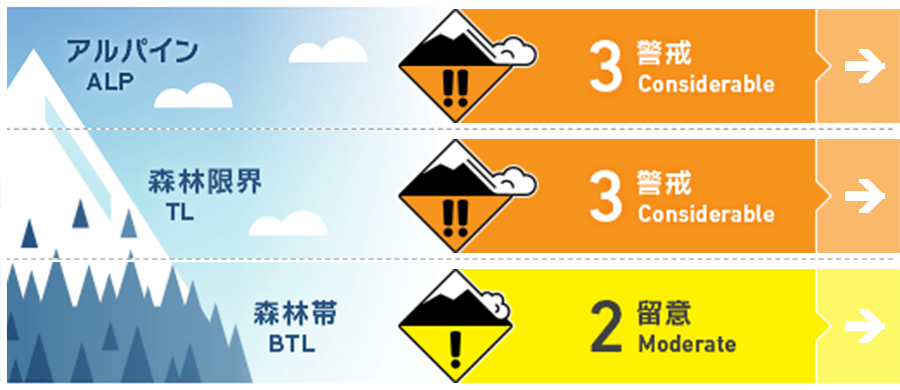
Hakuba
Alpine Low
Treeline Low
Below Treeline Fair In the upper area, act as "3 Considerable".
信頼度:○ good □ Fair △ Low
Travel and Terrain Advice
Compared to yesterday, the avalanche danger level is decreasing, but there is still enough instability in certain terrain for an avalanche to occur. This means that your terrain choice is very important on this day. Look for wind effects remaining on the snow surface and notice wind slab formations. You may notice changes in the snow by the feel of it underfoot. Look for simple, low angles slopes, avoiding convex or isolated terrain where the terrain is unlikely to support snowpack. The snow is cold, so even if you reduce the slope angle, you will still be able to enjoy the fresh snow as long as the wind is not affecting the slope. Also, remember to check for "terrain traps" below the slope. Please keep follow the principled course of action with safe terrain. Have a good day. Finally, a request to those involved in the accidents on Kazehuki-dake and Tohmi One. If possible, we would appreciate it if you could contact us via the contact form on our website. Thank you in advance.
Avalanche Problem
ウインドスラブ Wind slab


Strong westerly winds (average 10-15 m/s) have been blowing continuously along the main ridge since yesterday. We need to be very alert for wind slabs in terrain localities that are forming on the sides of the branch ridges and other areas.
ストームスラブ Storm slab


At higher elevations, be alert for slabs forming within the terrain that are protected from strong winds.
持続型スラブ Persistent slab


Faceting snow of note has been observed on the northern slope near the treeline. This snow is forming on top of Melt-Freeze crusts or ice layer from the rainfall on the 21st, and is the cause of the avalanche accident on Mt. Myoko Mitahara-yama. There is great uncertainty on the north to east facing slopes at higher elevations. Where the slab is thin, where the terrain does not support the snowpack, and on steep slopes where a combination of these factors are present, there is potential for large avalanches.
概要
Avalanche
Yesterday (2nd), a size 1-1.5 storm slab avalanche was reported in safety control at the ski area. In the mountain area, many shooting cracks and size 1 avalanches were reported on convex terrain, even in the forest. Avalanche accidents with injuries have been reported on Kazeyuki-dake and Tohmi One.
Snowpack
The overall feature of the snowpack in the northern Hakuba Valley region is an "upside-down structure," where dense snow from the subsequent winds is placed on top of the less cohesive snow that fell from the night of February 29 to March 1. Where this feature is strongly present, many shooting cracks and avalanches were observed yesterday. In addition, faceting of snow in the middle layer of the snowpack was observed on the northern slopes near the treeline, with cautionary test results. The situation is highly uncertain and requires additional investigation.
Weather
The Japan Meteorological Agency is forecasting southerly winds, sunny, then cloudy, with snow in the evening, and a daytime high of 8 °C (418 m elevation) for northern Nagano Prefecture. At Amedas Hakuba (elevation 703 m), the temperature is -6.9 °C (as of 5:00 pm). At 4:16 a.m. on March 3, the Nagano Prefectural Meteorological Office is forecasting 20 cm of snowfall for northern Nagano Prefecture over the next 24 hours until 6:00 a.m. on March 4.