
Avalanche Bulletin
更新日時: 2024/01/30 06:00
Niseko Yotei Yoichi Shiribeshi
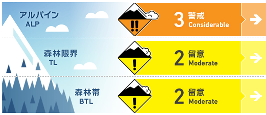
Alpine Fair Windslab will remain a concern after last weeks strong wind and snow in the alpine.
Treeline Good Many of the tree-line terrain has alpine like features and the possible windslab avalanche concern remains. Caution at the alpine/tree-line zone is advised especially around ridge tops and ridge top like features.
Below Treeline Good In the forest sheltered from the wind will be possible for loose dry avalanches especially on the stepper sheltered terrain. On solar aspects where it's possible a crust has formed, new dry snow could slide loose on the harder crust surface formed from the sun.
信頼度:○ good □ Fair △ Low
Travel and Terrain Advice
With mostly calm weather for today and tomorrow, it's a great chance to get out and get some good turns in. Take advantage in clear weather windows to look around and see how the strong winds last week have sculpted the snow and made wild snow features! North facing aspects have mostly stayed cool and solar aspects could have variable snow conditions. There are still many holes in the creek exits. If it looks like a hole...it is a hole... and caution is still advised in creek exits and the steep terrain that can lead into them.
Avalanche Problem
ウインドスラブ Wind slab


Possible wind slab will remain after days of calm winds. Look for the slopes where the snow has been stripped and then for the slopes where the stripped snow has been deposited to form windslab. Make careful terrain choices below ridge tops and ridge top like features where the snow has been deposited.
点発生乾雪雪崩 Dry Loose snow


Temps are forecasted to stay cool and with precipitation its possible to make for loose dry snow on sheltered terrain and on steep slopes.
概要
Avalanche
We are a few days apart from the strong winds and snowfall last week. The snow pack has had time to begin to settle and layers in the upper snow pack will become more stable with more time. There still exits the possible avalanche from windslab formation from last weeks strong wind and snowfall and will need caution.
Snowpack
The upper 50cm of the snowpack is starting to settle and bond with the old snow, however the more time the better for the layers to bond, especially with last weeks strong wind and snow weather event, some areas in the northern part the forecast zone received much more snow then others and will take a bit more time to settle. Reports of a crust from moments of clear weather and sun have been found on solar aspects in the forecast region and will need time to assess if a weak layer is forming around the crust.
Weather
The weather has been relatively calm since last weeks strong wind and snow with some areas in the forecast zone reporting sun and solar input on solar aspects. We are still in a mostly northwest flow for the region, that will switch to a more southernly flow Wednesday. The temps are forecasted to be below freezing and remain cold with pulses of snow.


