
Avalanche Bulletin
更新日時: 2023/11/30 07:00
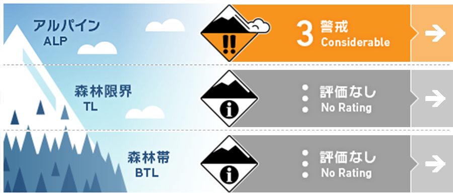
Tateyama
Alpine Fair Watch for increased snowfall in the future.
Treeline
Below Treeline
信頼度:○ good □ Fair △ Low
Travel and Terrain Advice
Conditions require careful route selection, but visibility is poor and avalanche terrain is difficult to recognize. Watch out for newly forming storm slabs on steep slopes; human-triggered avalanches continued through the 23rd. Be aware that this instability is localized, hard to find, and persistent. Beware of triggering from extremely steep slopes with thin snowpack. The slab and bed surface are hard, which allows the fracture line to spread significantly and increase the size of the avalanche. It is recommended to follow the action principle of reducing the time spent in avalanche start zones, tracks, and runout zones (avalanche terrain). There are many exposed "terrain traps" such as rocks and gullies that can increase the damage of even small avalanches. This concludes today's avalanche bulletin for Tateyama. We would like to thank everyone who provided us with information.
Avalanche Problem
ストームスラブ Storm slab


Beware of triggering on steep slopes.
持続型スラブ Persistent slab


Beware of triggering from areas with thin snow cover.
概要
Avalanche
No reports of new avalanches observed yesterday (29th) due to poor visibility.
Snowpack
At higher elevations, the new snowfall that began yesterday is expected to be more than 100 cm in blowdowns. It is being blown away on ridge tops and other wind-swept areas. The old snow is settling, but crusts are buried on the steep southerly slopes and bonding is unknown. The lower part of the snowpack is settling well and bonding is good, but instability remains due to local faceting, and avalanches were triggered from areas with thin snowpack until the 23rd. Caution is needed as new snowfall load is being applied here.
Weather
The temperature at 3000m as of 6:00 am is -14.6℃. In the vicinity of Murodo Terminal, there was more than 40 cm of wind-driven snowfall by morning in blowholes, and snowfall is still continuing with wind. According to the Japan Meteorological Agency, the winter pressure pattern is expected to continue, so it will generally rain at the foot of the mountains, with some snowfall in the mountainous areas. The forecast also predicts that some areas will be accompanied by thunderstorms until the evening.