
Avalanche Bulletin
更新日時: 2022/01/11 05:30
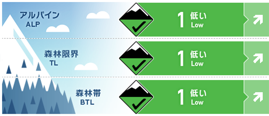
Myoko
Alpine Fair 南寄りの風で移動した雪に注意
Treeline Fair
Below Treeline Good 昇温あるいは降雨による影響に留意
信頼度:○ good □ Fair △ Low
Travel and Terrain Advice
Please be aware of any changes in conditions caused by weather phenomena. At low elevations, attention should be paid to Glide avalanche caused by warm air, and at high elevations, slabs caused by snow moved by winds from southwest to south. A strong winter type is forecast after the passage of the low pressure front, so once the weather starts to collapse, please consider that even if there is a weakening such as temporary snowfall, it is in the direction of complete deterioration as a whole. Whether it's weather or avalanches, it's important to think about the temporal and spatial scales of phenomena. If an incident occurs in which you cannot descend on your own, search and rescue will be extremely difficult due to the expected weather, so please take that into consideration and act with a safety margin.
Avalanche Problem
全層雪崩 Glide slab


日中の昇温および降雨等に注意
ウインドスラブ Wind slab


概要
Avalanche
Yesterday (10th), a point generation avalanche of size 1 wet snow was observed on a steep slope that was heavily exposed to solar radiation in the below treeline.
Snowpack
The snow of the previous stormy weather has settled down, and low-density snow from the early morning of the 9th has accumulated near the forest limit. Due to the effects of rising temperatures and solar radiation from yesterday, the snow surface layer melts on slopes at low elevations and heavily exposed to solar radiation, causing snowballs and point generation avalanches. Dry snow remains on the north side, and it is in good condition to raise the elevation in places where the wind is weak.
Weather
The Meteorological Agency predicts southern winds, rear, and west winds somewhat strong, cloudy, rain or snow from before noon, and a maximum temperature of 7℃ (elevation 13m) for the Joetsu region of Niigata prefecture. At Myoko Sasagamine (elevation 1310m), the temperature is -2℃ (as of 5:00), and there is no new snowfall in the past 24 hours. The low pressure, which is expected to develop rapidly, is moving northeast, and a cold front passes over the sky during the day, and it is forecast to become a strong winter type towards tomorrow.