
Avalanche Bulletin
更新日時: 2022/01/09 04:33
Kagura Tanigawa Hotaka
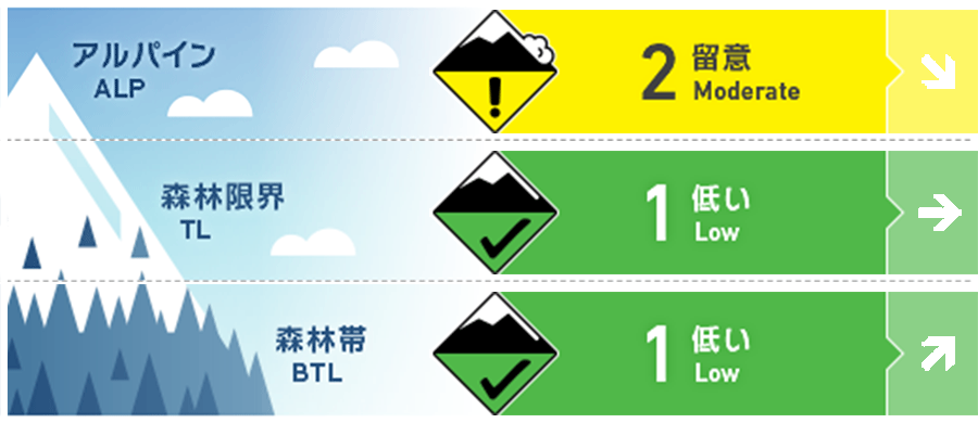
Alpine Fair
Treeline Fair
Below Treeline Good
信頼度:○ good □ Fair △ Low
Travel and Terrain Advice
Due to the strong winds until yesterday, snow has been blown away on the windy ridge. It is necessary to pay attention to the joining of wind slabs, which are formed on the extreme steep slopes just below the ridge, the ridge. Since there is still little snow at low elevations, there are exposed “terrain traps” such as deep gullies, cliffs, rocks, and standing trees that increase damage even if the size of avalanches that occur is small. It is forecast to clear up during the day. Also be aware of the possibility of wet and snow-point avalanches from large steep slopes to the south.
Avalanche Problem
ウインドスラブ Wind slab


概要
Avalanche
Yesterday (8th), there was a report of a wet snow point occurrence avalanche size 1 on a steep slope facing south near an altitude of 1400m
Snowpack
There was a snowfall of about 60 cm on top of the old snow where there was a lot of stormy weather until yesterday morning. This snowfall is gradually settling and coupling is progressing. Snow is blown away on the ridge line, and wind slabs are formed on the leeward ridges and just below the supporting ridges. On the steep slopes to the south, thawing and freezing crusts were formed due to the effects of yesterday's solar radiation. The bush is thick in the lower elevation zone, and there are holes in the swamp.
Weather
As of 4:00 p.m., the temperature is -9.2℃ at AMeDAS Fujiwara, and there is no new snowfall for the past 12 hours. According to the announcement from the Japan Meteorological Agency at 16:00 on the 8th, it is forecast that it will clear up gently covered by high pressure, but due to the front passing through northern Japan and being affected by moist air, it is expected to become cloudy in the evening.