
Avalanche Bulletin
更新日時: 2021/12/23 07:00
Niseko Yotei Yoichi Shiribeshi
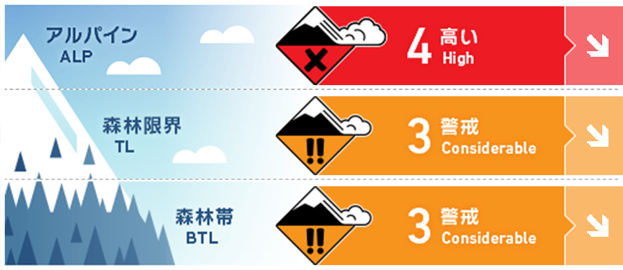
Alpine Fair 暴風と大量降雪が風下側に大きな負荷を掛けています。このまとまった降雪が落ち着くまで十分な注意を払う必要があります。Extreme wind and heavy snowfall have loaded leeward slopes. Exercise caution until the new snow has had a chance to bond to the old storm snow.
Treeline Fair すべての斜面でスラブ形成の証拠を探す必要があります。Look for evidence of slab formation on all aspects at treeline.
Below Treeline Fair 少雪であった森林帯でも雪崩を発生させるうるほどの積雪深となりました。The BTL zone now has enough snow for slab avalanches to be a concern.
信頼度:○ good □ Fair △ Low
Travel and Terrain Advice
Large slopes with a large accumulation of snow should be avoided until the instability of the snow cover is eliminated. The danger of avalanches continues, so please cherish basic behavioral patterns, such as taking actions that keep your companions in sight at all times. Avoid heavily loaded leeward slopes until they had a chance to stabilize. Snow immersion hazard continues to be a serious concern so keep track of your friends even in non-avalanche terrain.
Avalanche Problem
点発生乾雪雪崩 Dry Loose snow


急斜面には点発生雪崩の危険があります。Loose dry activity can be expected on steep slopes.
ストームスラブ Storm slab


森林限界付近では、強風から守られた場所にあるストームスラブの存在に特に注意が必要です。Storm slab may be lurking in protected areas below the treeline.
ウインドスラブ Wind slab


強風と大量降雪により、風下側の積雪は急速に増えています。自然発生の雪崩は荒天の最中に起きている可能性がありますが、移動可能な雪が多量にありますので、再配分された積雪によって、雪崩の危険は高いままです。Strong winds and heavy snow have rapidly loaded leeward slopes. Many natural avalanches may have already released during the storm but could have easily re-loaded.
概要
Avalanche
On December 21, an avalanche of size 1.5 was observed and reported on the eastern slope of Mt. Shiribetsu, near an altitude of 1000m. A Size 1.5 avalanche released to ground at 1000m East Aspect Shiribetsu on Dec. 21.
Snowpack
There has been a 40-60 cm snowfall in the last 24 hours due to a strong snowstorm. As a result, the amount of snowfall in the past week has exceeded 1 m, and the week interface within the fresh snow also remains. This series of stormy snow rests on top of the old snow, which binds well and is stable. The overall structure of the snow cover has a higher density of the lower layer, and the lower the density of the upper layer, and has a forward structure. An intense storm has delivered another 40-60cms of new snow in the past 24 hours. The settled accumulation over the past week is now well over a meter with some interfaces in the storm layers. The Storm snow forms most of the snowpack and its on a well consolidated base. Overall the snowpack is right side up and rounding.
Weather
Heavy snowfall has calmed down, and mild snowfall and moderate winds due to northwesterly winds are forecast today tomorrow. The temperature will be below freezing throughout the area, and strong chills will enter from Friday night, and the temperature is expected to drop. The intense storm has passed but a steady NW flow will continue to bring lighter snowfall and moderate winds to the region today and tomorrow. Temperatures will remain below zero across the region and expected to drop further Friday night.


