
Avalanche Bulletin
更新日時: 2021/12/21 07:00
Niseko Yotei Yoichi Shiribeshi
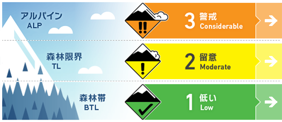
Alpine Low アルパインエリアの観察情報は限定的ながら、風下側にはウインドスラブの形成が強く疑われる状況。Alpine observations are limited however it is expected that Wind slab has formed on leeward features.
Treeline Good ストームスラブと旧雪の結合を上げるまで、大きく急な斜面は避けるように。Avoid large, steep slopes until the storm slab has bonded to the lower pack.
Below Treeline Good 荒天の雪は焼結を進めつつ、旧雪とよく結合しています。積雪のアンカーとなるブッシュなどが、まだ雪面は雪面直下に多数残っています。Storm snow is consolidating and bonding well to the old snow surface. Lots of anchors remain above and just below the snow surface.
信頼度:○ good □ Fair △ Low
Travel and Terrain Advice
The snow conditions in the backcountry are very soft and deep at the beginning of the season. Therefore, it is necessary to pay attention to obstacles that are not sufficiently buried and the cavities formed around them. Very deep conditions exist in the backcountry so be aware of snow immersion hazards Particularly with large voids around partially buried obstacles.
Avalanche Problem
点発生乾雪雪崩 Dry Loose snow


急斜面では滑走者の刺激で点発生雪崩が起こりうる状態です。Expect loose dry avalanches to be reactive to skier triggers on steep slopes.
ウインドスラブ Wind slab


中程度から強い風がアルパインエリアでは、荒天の期間、吹き続けており、多量の雪が移動しました。稜線の下方地形で、風で移動した雪が堆積した状況を探してみてください。Lots of snow has been available for transport and moderate to strong alpine winds have persisted throughout the storm. Look for heavily loaded features just below ridge crest.
ストームスラブ Storm slab


本日は日中の昇温の影響を考えてください。また、ストームスラブ内にはウイークインターフェイスが存在しているので注意が必要です。Monitor the transition of the new snow into a slab particularly as temperatures warm during the day Tuesday. Also be aware of interfaces within the storm layers.
概要
Avalanche
A point avalanche of size 1 induced by a runner was observed and reported on December 19. Skier triggered size 1 Loose dry avalanches were observed on Dec. 19
Snowpack
There was a snowfall of 5 to 15 cm until this morning, and the amount of snowfall due to this stormy weather was about 70 cm. There is a surface with weak binding strength about 40 cm below the surface layer, but the surface layer remains low density. The snow in stormy weather, about 30 cm below it, has increased the bonding strength and is well combined with the old snow. An additional 5-15cms of new snow arrived last night bringing the settled storm total to ~ 70cms. There is a notable interface within the storm snow down 40cms however the top layer Remains very low density with no slab quality. The lower 30cms of Storm Snow is consolidating into a slab but bonding well to the old Snow surface. The lower pack is well consolidated.
Weather
It is forecast that there will be little snowfall today, the temperature will be mild, the freezing altitude will rise to 350 m, and then cool down late at night. From tonight to tomorrow, there are consolidated snowfall forecasts. Today will bring lighter snowfall and milder temperatures with the freezing level rising to 350m before dropping back down this later evening. Heavy snowfall will resume tonight and through the day tomorrow. Winds will be light from the South this morning before moderate West to NW winds take over later in the day.


