
雪崩情報
更新日時: 2021/02/27 06:00
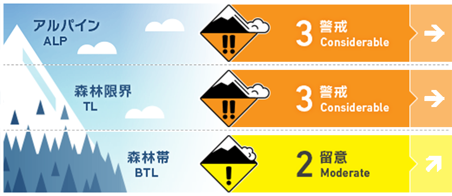
ニセコ・羊蹄・余市・尻別
アルパイン Fair Expect to find wind slab on Easterly aspects in the alpine today. アルパインでは東側の斜面にウインドスラブが形成
森林限界 Fair Pockets of wind slab on Easterly aspects have formed after a week of snowfall and wind. この一週間の降雪と風の影響で東側の局所にウインドスラブが形成
森林帯 Fair As we move through the weekend warmer temperatures on Sunday are likely to produce loose wet activity in steep terrain. 明日に向けて昇温が予報されており、標高の低い急斜面では濡れた雪による雪崩に留意を
信頼度:○ good □ Fair △ Low
行動と地形の助言
Look for pockets of wind pressed snow in the alpine across Easterly aspects, this will be a sign of wind slab development. Be wary on ridgelines as cornice appear to be brittle and are fracturing easily. If temperatures increase over the weekend avoid stopping below any glide cracks. アルパインエリアの東側には、風で運ばれた雪による局所のスラブ形成がありうることを考えてください。稜線に形成した雪庇はもろく、崩落しやす状態ですので、注意が必要です。昇温を感じたら、特に、グライドクラックのある斜面の下では留まらないように注意してください。
留意すべき雪崩
点発生湿雪雪崩 Wet Loose snow


If temperatures increase on Sunday we can expect to see wet loose activity in steep terrain. 日曜に昇温が予報されており、急峻な地形で濡れた雪の雪崩に注意する必要があります。
ウインドスラブ Wind slab


A week of strong to gale North to North West winds have produced pockets of wind slab across Easterly aspects at higher elevations. These slabs overlie a buried crust layer producing a bed surface for them to run on. この一週間、継続して北から北西の強風が吹き、標高の高い場所を中心に、東斜面の局所にウインドスラブが形成しました。このスラブは硬いクラストの上に形成されていますので、雪崩にとって良い滑り面となりえます。
概要
雪崩
Multiple reports of slab avalanche activity up to size 2 on Easterly aspects over the previous week. These slabs appear to be running on a buried crust. There have also been numerous cornice failures. 今週、東側の斜面でsize 2の雪崩が、複数、観察報告されています。雪崩は硬いクラストを滑り面として発生していることが推察されています。また、多数の雪庇の崩落も観察されています。
積雪
The lower snowpack is now punctuated by multiple crusts which have formed by previous rain and sun events. Over the last week, we have received steady snowfall with strong to gale West to North West winds which have produced pockets of slab at higher elevations. 積雪下層は、これまでの昇温や降雨で形成した複数のクラストで構成されています。これまでの西から北西の風を伴う降雪があり、標高の高い場所を中心にスラブが局所に形成しています。
天候
A high-pressure system moves across Hokkaido throughout the weekend bringing more settled weather and lower wind speeds. Expect the wind direction to move from a Northerly flow round to the South West on Sunday resulting in a temperature spike during the day. 高気圧が北海道上空を通過し、この週末は天候が落ち着き、風も収まる予報が出ています。日中は、風皇が北から南西に変わり、気温も上昇する予報となっています。


