
Avalanche Bulletin
更新日時: 2021/02/06 06:00
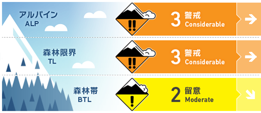
Niseko Yotei Yoichi Shiribeshi
Alpine Low Multiple days of snowfall has occurred with strong to gale winds from the west we expect slabs to have formed in both the treeline and alpine. 強風の西風を伴う降雪が数日続いていますので、森林限界からアルパインには、それによるスラブの形成に留意を。
Treeline Fair Multiple days of snowfall has occurred with strong to gale winds from the west we expect slabs to have formed in both the treeline and alpine. 強風の西風を伴う降雪が数日続いていますので、森林限界からアルパインには、それによるスラブの形成に留意を。
Below Treeline Fair A brief warming period on Saturday morning may produce loose wet point release activity in steep terrain. 本日(土曜)の昇温は急峻な地形で濡れた雪による点発生雪崩の可能性を高めます。
信頼度:○ good □ Fair △ Low
Travel and Terrain Advice
Below treeline, the brief spike in temperatures on Saturday morning may produce wet loose activity in seep terrain be wary of steep features above terrain traps before temperatures lower. At higher elevations look for signs of smooth pressed snow across the Easterly half where slabs may have formed in protected areas. 森林限界から標高が低い場所では、昇温に伴う濡れた雪の雪崩に注意してください。地形の罠の上方にある急峻な地形などを見逃さないように。標高が高い、東側の斜面では、風が比較的弱い場所に形成しているスラブに注意してください。その雪面は風でならされ、綺麗な表情を見せているかも知れません。騙されないように。
Avalanche Problem
点発生湿雪雪崩 Wet Loose snow


A brief warming period through midday on Saturday may produce wet loose activity in steep terrain. This will quickly stabilise when temperatures lower later in the day. 本日(土曜)の昼頃までの昇温は、急峻な地形で濡れた雪による点発生雪崩の可能性を高めます。ただし、気温低下と共に、すぐに安定化するのが通常です。
ウインドスラブ Wind slab


Over the last week, we have received a considerable amount of new snow and strong to gale winds from the West. These winds will have transported a large amount of new snow to the Easterly lee slopes where winds slab may have formed at higher elevations. これまで週を通して、かなり強い西風と降雪の影響を受けています。風によって、大量の雪が風下側である東斜面へと移動し、特に標高が高いところでのウインドスラブの形成に注意する必要があります。
ストームスラブ Storm slab


With multiple days of new snow accumulating over the past week storm slab may be found on all aspects in the tree line and alpine. この一週間、複数の日で降雪が続きましたので、森林限界からアルパインのエリアでは広範囲にストームスラブが形成されています。
概要
Avalanche
No new activity has been reported. 真新しい雪崩の発生報告は入っていません。
Snowpack
The snowpack has increased over the previous week with over a metre of new snow being recorded. Below this latest new snow, multiple crusts can found which are proving to be reactive in tests these crusts may act as a trigger if they become overloaded by further load. Stong to gale Westerly winds will have blown some of this latest new snow across to the Easterly half and may have produced wind slabs in protected areas at higher elevations. 積雪深は、先週より約1m増えています。この新雪の下には、複数のクラストが存在しており、テストなどでは反応を示しています。ここから、潜在的に雪崩を起こしうるポテンシャルがあると判断されています。まとまった降雪の一部は、継続的に吹いた強い西風で東へと移動しており、ウインドスラブの発達が疑われています。
Weather
After a windy week, we are expected to have a much calmer weekend with winds speeds dropping and snowfall easing slightly. A spike in temperatures on Saturday morning will see the lower evaluations warm to above freezing before the wind direction returns back to a more Northerly flow in the afternoon. 風と降雪は収まり、穏やかな週末になる予報がでています。本日(土曜)の朝は気温が上がりますが、午後には風向が北へと変わり、氷点下へと気温も下がる予報となっています。


