
Avalanche Bulletin
更新日時: 2021/01/30 07:00
Niseko Yotei Yoichi Shiribeshi
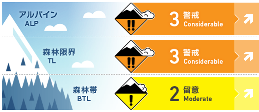
Alpine Low Strong Southerly winds have now shifted to the NW. Expect complex loading patterns as new snow arrives on Saturday. 南寄りの風は、北西へと変わりました。土曜の降雪は複雑な堆積になりそうです。
Treeline Fair Strong Southerly winds have now shifted to the NW. Expect complex loading patterns as new snow arrives on Saturday. 南寄りの風は、北西へと変わりました。土曜の降雪は複雑な堆積になりそうです。
Below Treeline Fair Widespread temperature and solar crusts will delay the bond of new snow to the old surface. 広範囲で日射と昇温によるクラストがあり、新雪と旧雪の結合はゆっくりとなります。
信頼度:○ good □ Fair △ Low
Travel and Terrain Advice
Recent mild temps and strong winds have left crusts exposed across the region. These crusts will create an ideal sliding surface as new snow arrives over the weekend. Make conservative terrain choices until the new snow has had an opportunity to bond to the old surface 最近の高めの気温と強風により、この地域ではクラストが形成しています。この上に、現在の荒天の雪が載りますので、クラストはよい滑り面となりえます。新雪と旧雪の結合状態が向上するまで、慎重に地形を選択する必要があります。.
Avalanche Problem
点発生乾雪雪崩 Dry Loose snow


Cold, dry snow is expected to arrive during the day Saturday and on many aspects and elevations will land on exposed crusts. Expect this snow to have difficulty bonding and therefore run easily particularly on steep slopes 低温でドライな雪が降ることで、硬い斜面が露出しているすべての標高帯と方位で点発生雪崩の危険があります。特に急斜面では簡単に誘発します。
ストームスラブ Storm slab


The storm slab problem will be an increasing concern as new snow arrives over the weekend. Be particularly cautious if new snow exceeds 30cm. この週末は、ストームスラブに警戒が必要です。特に新雪が30cmを越えた場合、注意してください。
ウインドスラブ Wind slab

Wind slab developed on North and East aspects yesterday. New snow and wind from the NW on Saturday will create complex loading patterns. Use extra caution on any leeward terrain. 昨日、北から東の斜面でウインドスラブが形成しています。本日から北西の風を伴う新雪が降り、複雑な堆積パターンとなります。風下側の斜面に特別な注意が必要です。
概要
Avalanche
Test slopes produced easy wind slab failures on Friday Jan. 29 金曜日、調査斜面にてウインドスラブの雪崩を誘発しています。
Snowpack
Several days of calm sunny weather at the start of the week created a melt/freeze crust on all solar aspects. This was followed by mild weather allowing a crust to form on all aspects up to 800m. Thursday night brought approximately 30cms of heavy snow to upper elevations with strong Southerly winds moving most of this snow to North and East aspects leaving a scoured crust on windward slopes. 今週は、週の始めの数日、穏やかな晴天が続きましたので、日射の当たる斜面には融解凍結クラストが形成しました。穏やかな気象はその後も続き、標高800mまでのすべての斜面でクラストが形成しました。木曜日の夜、標高の高いところでは30c程度の降雪がああり、強い南寄りの風が、この新雪を北から東の斜面に移動させています。
Weather
Temperatures have dropped and a NW flow has resumed. Moderate to heavy snowfall is expected to pick up around mid-day Saturday accompanied by strong NW winds. Winds will ease off overnight with snow continuing through to the end of the weekend. 気温が低下し、冬型の気圧配置による北西の風へと移行しています。中程度から大雪の予報が出ており、この後、土曜の昼に向けて、降雪は強い北西の風を伴う予報です。風は一晩で和らぐ予報が出ていますが、降雪は週を通じであるとのことです。


