Avalanche Bulletin
Overview of Avalanche Bulletin
Purpose
JAN’s avalanche bulletin is released for the purpose of supporting the trip plans of mountain users. Therefore, information on what type of avalanche exists in which locations and how likely it is that it might occur has been published in an easy to digest manner that incorporates illustrations. This information has been created from analyzing and evaluating various data observed in the field by avalanche professionals with specialized education and training in avalanches. In addition, "travel advisory" for the given conditions are attached to this information for the purpose of having mountain users take action to mitigate risks in accordance with the conditions. This avalanche bulletin aims to contribute to reducing the occurrence rate of avalanche incidents and to mitigate damage if they do occur by providing decision making material to the user(s).
Characteristics and backbone
JAN’s avalanche bulletin is standardized avalanche information that is identical to public announcements published by specialized avalanche associations in North America. This was made possible by the long years of collaboration with the Canadian Avalanche Association.
『
CAAJournal_RisingSun_translated_2
』の記事
『日本雪崩ネットワークにおける雪崩情報発表への実践的アプローチ』
日本雪氷学会「雪氷」76巻6号451-460頁
Limitations and liability of information
The reliability of data changes depending on factors such as the volume and quality of data used, special distribution, temporal changes and type of instability, the anomalous nature of an event, and the experience of the person evaluating data. Issued avalanche bulletin expresses its reliability on a scale of Good / Fair / Poor with reasons for the rating attached. Also, this avalanche bulletin is private information issued by the nonprofit organization Japan Avalanche Network and differs from avalanche warnings issued by the Japan Meteorological Agency. Also, while avalanche bulletin forecasts avalanches a few days ahead as part of its format, this infringes upon the Meteorological Service Act in Japan, so JAN’s avalanche bulletin takes the form of a Nowcast which assesses hazard levels at any given time based on data observed at the site. Avalanche hazard change after these reports are issued depending on weather conditions, and the type of instability factors present.
リンク(Link):気象庁(Japan Meteorological Agency)の「
なだれ注意報 "avalanche warning"
」
カナダでの雪崩情報 「
Avalanche Canada
」
Information Components
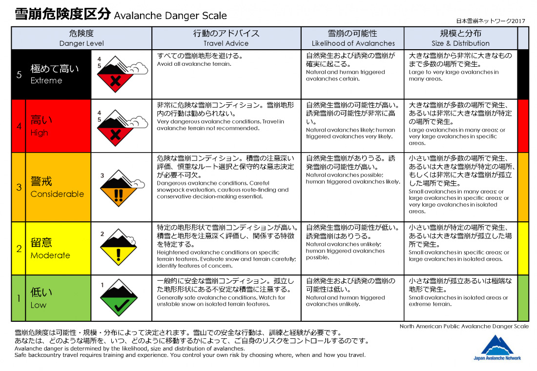
Avalanche Danger Rating
This is a five-tiered hazard assessment determined by the possibility, size, and distribution of an avalanche. Each element (possibility, size, and distribution) is further evaluated on respective tiered assessment axes. Hazard levels are categorized according to defined terminology, so avalanche hazard does not simply rise on a linear scale from Low to Extreme. Specific hazard elements are described in “Avalanche Problem” and “Overview.” In other words, the avalanche danger rating only serves as an entry point for the mountain user to consider the hazard of an avalanche. Also, the arrow shown to the right of the hazard level shows the current trend of the hazard level at the time that the avalanche bulletin is announced. If the arrow point is rising to the right, it shows that "currently, hazard level is on a rising trend."
Avalanche Problem
Avalanche Problem refers to information that describes which types of avalanches bring about which types of hazards in the Avalanche Danger Rating. Avalanches vary from those that resolve themselves within a few days, to those that continue to carry the hazard of inducing further problems over the course of a few weeks or more. Therefore, typical avalanches that exist in mountainous areas have been categorized into seven categories, and each are expressed in terms of the altitude in which they exist, direction, possibility of being triggered, and the possible size, expressed with the aid of illustrations.
リンク(Link): 雪崩の種類(Avalanche Types, PDF)
Overview
Fairly detailed information based on data observed in the field is stated for avalanche observations, snowpack condition, and the weather. In particular, Avalanche observations contains important information so please be sure to check this part.
Travel Advisory
Advice to take action to mitigate risk is stated in a simple manner. Avalanche bulletin expresses the overall characteristics of snowpack, so judging the terrain, using it wisely, and employing basic guidelines for actions is very important in mitigating avalanche risk.
Avalanche Danger Rating
This is the avalanche danger rating used in avalanche bulletin from JAN. It is identical to the danger rating studied and proposed by the Avalanche Decision-making Framework for Amateur Recreationalists 2 (ADFAR2), composed of professionals working in the front lines of avalanche bulletin in North America.
リンク(Link): 雪崩危険度区分(Avalanche Dander Rating, PDF)
Avalanche Size
This is a category used in JAN’s avalanche bulletin. The category is in accordance with the Observation Guidelines and Recording Standards for Weather, Snowpack and Avalanches(OGRS). The total length of the path run is a rule of thumb and is categorized by considering the slab thickness and damage received by the objects in its path. Decimal values, (1.5, etc.) may also be used.
リンク(Link): 『気象・積雪・雪崩の観察と記録のガイドライン 2017』(OGRS)
| Size | Destructive potential | Typical mass, Typical path length |
|---|---|---|
| size 1 | Relatively harmless to people. | 10t・10m |
| size 2 | Could bury, injure, or kill a person. | 10二乗t・100m |
| size 3 | Could bury and destroy a car, damage a truck, destroy a wood-frame house or break a few trees. | 10三乗t・1000m |
| size 4 | Could destroy a railway car, large truck, several buildings or a forest area of approximately 4 hectares. | 10四乗t・2000m |
| size 5 | Largest snow avalanche known. Could destroy a village or a forest area of approximately 40 hectares. | 10五乗t・3000m |
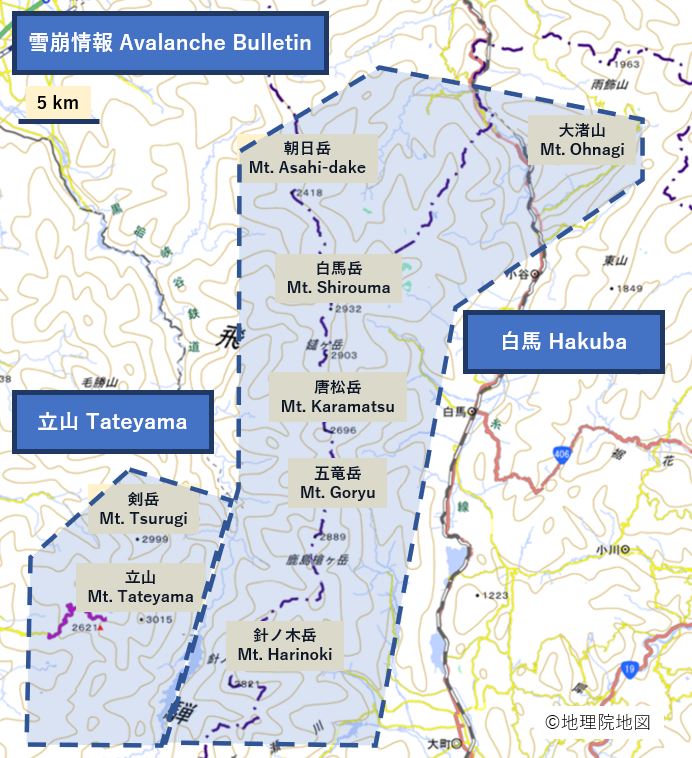
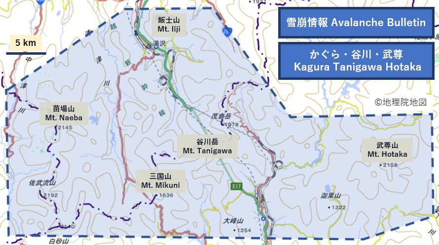
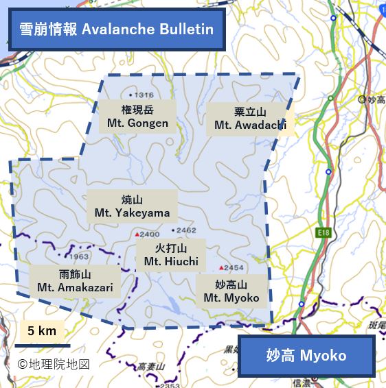
Reporting Area
Hakuba Area and Tateyama Area
Kagura Tanigawa Hotaka Area
Myoko Area
Niseko, Yotei, Yoichi, Shiribetsu Area
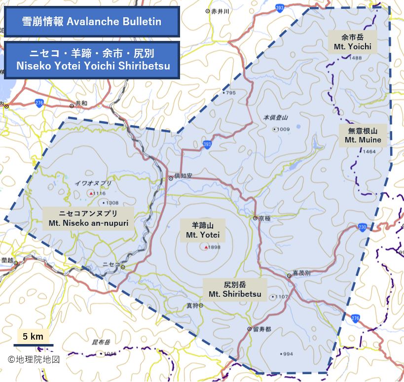
Avalanche bulletin is mainly reported in each region in the area bounded by the orange dotted lines, communicating avalanche hazard and other features. Though the following information is constantly related in avalanche bulletin, it is of note that in the Hakuba area, snowfall increases as one moves northward, while in contrast, in the Tanigawa Hotaka area, snowfall reduces as one moves from the Tanigawa area to the Hotaka area. These impact snow accumulation volumes.
On using this service
Deftly using avalanche bulletin requires knowledge and experience. JAN Avalanche Bulletin is a Nowcast stating conditions as in the morning. It is not a forecast. Avalanche hazard may change during the day due to weather and snowfall. Also, please be aware that statistical data shows that avalanche fatalities in the recreational field largely occur during times when avalanche danger rating is "considerable".
リンク(Link): High Danger isn't High Risk.
If you ...
1) have little experience with mountains and have yet to receive training on avalanche...
- visit mountains with a person with sufficient experience who has received appropriate training
- use a guide that holds official qualifications (Japan Mountain Guides Association)
- participate in the JAN safety seminar "Avalanche Night"
2) have some experience with mountains but have not receive appropriate training...
- do not enter avalanche terrain if you notice three of any items below:
- New avalanches (in the last two days)
- Concentrated snow accumulation or snow movement due to wind (in the last two days)
- Avalanche Danger Rating is "Considerable" or more
- Terrain Trap
- Rapid rise in temperature
- Signs of instability, such as shooting crack or whumpfing (the sound of snow collapsing)
- Participate in the JAN avalanche course "Safety Camp"
3) have participated in an avalanche workshop on the snow and are accumulating mountain experience...
- check Avalanche Problem and consider whether the location has a high possibility of avalanches.
- as noted in the Overview, do not take avalanches and severe weather conditions that occurred the day before lightly.
- remember that avalanche safety is always terrain, terrain, terrain
4) are a guide or other professional...
- consider avalanche information that communicates the overall situation and diversity of localized snow conditions.
- if important signs are noted, you can contribute to the avalanche community by providing information to JAN. Follow "this link" to post avalanche observations, etc.