
雪崩情報
更新日時: 2022/03/03 07:00
ニセコ・羊蹄・余市・尻別
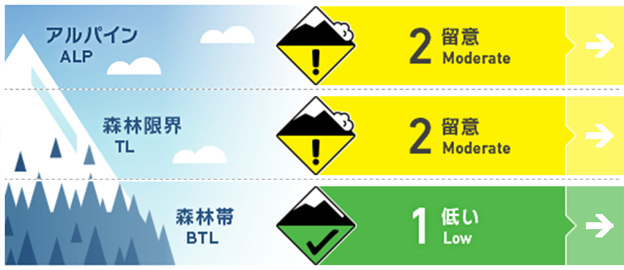
アルパイン Fair 稜線の風下に形成した局所のウインドスラブに注意Isolated pockets of wind slab on the lee of ridgelines.
森林限界 Good 急な凸状地形に孤立して残る局所のウインドスラブに注意Pockets of wind slab may be found on knolls and steep, isolated terrain features
森林帯 Good この数日の昇温でグライドクラックが成長していますGlide cracks continue to grow with the recent warm temperatures
信頼度:○ good □ Fair △ Low
行動と地形の助言
グライドクラックは引き続き、危険な状態にあります。滑走をコントロールし、メンバー全員が安全地帯まで移動するまで、グループ全体を上手にマネジメントする必要があります。積雪表面の雪は、日中の昇温や日射で急激に変化する可能性があります。標高が高い場合、乾いた雪も重くなり、樹木の上に載った雪の落雪も生じます。晴れた日は自分の上方にあるものにも注意を向けてみてください。Glide cracks will continue to be a hazard and will require skiing under control and keeping everyone in the group accounted for while descending. Surface snow conditions can change quickly in the heat of the day and with elevation resulting in dry snow becoming heavy very suddenly. Blocks of firm snow and ice that have fallen from trees are littering the snow surface and care must be taken to avoid them also watch for what is above you when stopping on sunny days.
留意すべき雪崩
ウインドスラブ Wind slab


雪崩情報の発表地域の風向は、いつものように北西から西の風で、その風速も弱いから強いまで多様でした。しかし、風で移動される雪は、既に限定的になっているため、ウインドスラブの形成は限定的であると考えられます。風下斜面、特に30°を超える急斜面などの局所に孤立した形でウインドスラブが残る可能性あります。Winds speeds over the forecast area have ranged from light to strong in the Alpine and at Tree Line coming from the familiar WNW direction but with limited new snow available for transport new wind slab formation may be minimal. Continue to use caution on lee slopes, particularly steep slopes greater than 30 degrees, and the lee of knolls in consequential terrain, where isolated pockets of wind slab may remain.
概要
雪崩
自然発生および人的誘発、いずれの雪崩も報告されていません。No natural nor human-triggered avalanches have been reported.
積雪
地域に春が来たようです。最後のまとまった降雪が降る前に形成した表面霜(2月16日の週)は、まだ重要な層として積雪内に残っています。その層の上には、十分に焼結した60-80 cmのスラブが載っており、森林限界付近で実施された観察では顕著な脆弱性は示していません。It appears spring has begun to make it's self-known across the region. A buried weak layer (Surface Hoar) formed in the week of 16th of Feb prior to the last significant snowfall and remains visible in the pack. Tests of this layer suggest that 60 to 80 cm of well-bonded snow is above this and is not reacting on the instability in areas where we have been able to gather information at treeline.
天候
次の雪崩情報を発表するまでの間に、低気圧が西から移動し、土曜の朝までには冬型となる予報がでています。風は次第に強まるとのことです。本日については、夕方までに多少の降雪があり、明日は降雪はなく、日差しがある予報となっています。Over the forecast period, winds will be light to moderate with strong gusts from variable directions as a low-pressure system passes over from the West later today and the next front moves into position by Saturday morning. Modest amounts of snow will fall from mid-morning to early evening today with little snowfall predicted for Friday and periods of sunshine forecast.


