
雪崩情報
更新日時: 2022/03/01 07:00
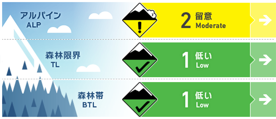
ニセコ・羊蹄・余市・尻別
アルパイン Good 稜線付近の地形ポケットにウインドスラブが残っています。Isolated pockets of wind slab remain around ridgeline.
森林限界 Good 孤立した地形に、ごく小規模のウインドスラブがあるかも知れません。Low volume pockets of surface wind slab can be found in isolated terrian.
森林帯 Good この数日でグライドクラックが成長しています。重大な怪我の原因になりえます。Glide cracks have grown over the last few days creating a significant hazard for injury.
信頼度:○ good □ Fair △ Low
行動と地形の助言
この数日、まとまった新たな降雪がないこともあり、バックカントリーに入る人は、ノートラックの斜面を探しています。止まるときは安全な位置を選び、自分の上下に他の人がいないか注意してください。グライドクラックは成長しており、大きな「地形の罠」といえます。With not much in the way of new snow over the last few days, plenty of people will be looking to the backcountry for some fresher turns. Be mindful of who may be above you when choosing safe places to stop. Glide cracks have grown large over the last few days and are a big terrain trap.
留意すべき雪崩
ウインドスラブ Wind slab


先週末から標高の高いところでは強風が吹き、飛雪も観察されています。これにより、北西の風によるウインドスラブが風下側に形成されました。ただし、このスラブは特定の斜面の地形ポケットにあると考えられているため、皆さんが行動しながら、風で移動した雪の兆候や形成間もない雪庇の形成などを頼りに、その危険な場所を見つけてください。At upper elevations, we have had strong to gale force winds over the weekend and the early part of this week. Wind transported snow was observed at ridgeline creating pockets of slab lee to the NW winds. These slabs are expected to be in specific terrain so look signs of fresh wind pressed snow and fresh cornice development as an indication of where they have formed.
概要
雪崩
尻別岳の西側の斜面にて、既にできていたグライドクラックから全層雪崩が発生しているとの報告を受けています。この雪崩の発生は、2月26日の昇温していた期間に発生したものと考えられています。A large glide crack release was reported on Mt Shiribetsu on a Westley aspect. It is expected that this release occurred during the warming period on the 26th Feb.
積雪
数日間、凍結高度は700 m付近まで上昇した後、今朝までに再び、下降してきています。稜線付近の地形ポケットにはウインドスラブが残っています。昨日(2月28日)、標高800 mの北西斜面にて調査を行いましたが、雪面から80 cmの位置に表面霜が埋没しており、テスト結果が出ています。この留意すべき層についての空間的多様性については、さらなる調査を必要としています。After multiple days of the freezing level climbing up to 700m meters and now dropping again we expect to be greeted by a firm snow surface early on Tuesday. Above this pockets of wind slab remains around ridgeline. Testing on the 28th of Feb at 800m on a NW aspect resulted in moderate compression test failures on a buried layer of surface hoar down 80cm. Further investigation of the spatial variability of this layer is required.
天候
風向が南から西へと変わり、降雪が予報されています。凍結高度は一旦、上昇する可能性があり、水曜日には晴れ間もあるとのことです。風は弱から中程度と予報されています。We will receive snow flurries over the next few days as the wind direction jumps from the South to the West. Freezing levels may rise again and we could see periods of sunshine on Wednesday. Winds are expected to remain low to moderate.


