
雪崩情報
更新日時: 2022/02/22 07:00
ニセコ・羊蹄・余市・尻別
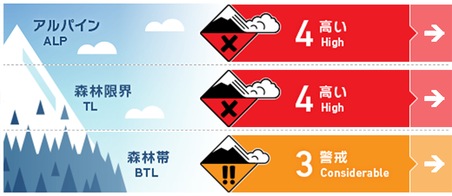
アルパイン Fair アルパインエリアでは、ストームスラブの誘発の可能性がとても高い状態です。Storm slab avalanches are very likely to be triggered in the Alpine at present.
森林限界 Fair このレベルの危険度の際、ストームスラブの雪崩は、自然発生と人的な誘発、いずれでもとても可能性が高い状態にあります。This latest storm event is very likely to produce natural and human-triggered storm slabs.
森林帯 Fair 雪崩を発生させうるほどの傾斜があれば、小さい地形であっても、狭い沢や川底などの地形の罠が組み合わさることで、重大な結末となりえます。グライドクラックを斜面上方から視認することは困難です。Micro features that are steep enough to slide may have high consequences especially when combined with terrain traps such as river beds and gullies. Open glide cracks will also be very difficult to see from above.
信頼度:○ good □ Fair △ Low
行動と地形の助言
北西の暴風と大量降雪により、荒天の期間におけるフィールドの観察は限界がありました。直近の新雪が落ち着き、さらに情報を収集できるようになるまで、雪崩地形から離れることをおすすめします。With gale North West winds and a huge amount of new snow we have had limited ability for observations during the storm, we recommend staying out of avalanche terrain until the latest new snow has time to settle and we are able to gather further information.
留意すべき雪崩
ストームスラブ Storm slab


長時間の大量降雪と北西の強風により、森林限界とアルパインの標高帯において、ストームスラブが形成しています。過去36時間において、自然発生の雪崩が起こる雪崩サイクルにあったと考えることができ、今後、数日間は、複数の方位にて、人的な誘発による雪崩の可能性が高いままとなります。雪崩地形内の行動は、現時点ではおすすめできません。After a prolonged period of heavy snowfall and gale North Westerly winds storm slabs will have formed in the Treeline and Alpine. We expect a natural cycle of avalanche activity to have occurred over the previous 36 hours and it is very likely human-triggered avalanches can be expected on multiple aspects in the coming days. Backcountry travel in avalanche terrain is not advised at present.
概要
雪崩
2月20日、人を埋めるに十分な雪の量が動く雪崩、サイズ2が報告されました。このストームスラブによる雪崩は、イワオヌプリの標高1,000 m、北東斜面で人的な誘発によるものです。この雪崩による怪我人の発生はありません。A size 2 (large enough to bury a person) was reported on the 20th Feb. This slab was human triggered on a NE aspect on Mt Iwaonupuri at approximately 1000m. There were no reports of injury associated with this incident.
積雪
直近の暴風雪によって、100 cmを遥かに超える降雪がありました。この大量降雪の前、日射を浴びる斜面では融解凍結クラストが形成しており、先週の南風では、風下側に雪を移動させることで、地形局所にスラブが形成していました。今回の降雪は、こうした複数の特徴を持つ旧雪とその境界面に大きな負荷を掛けています。We have now received well in excess of 100cm of new snow during this latest storm cycle. Previous to this loading solar aspects across the South had a crust on the surface. A period of Southerly winds last week redistributed snow onto lee slopes and pockets of slab had formed at higher elevations. This latest snowfall may overload the old snow interface on multiple aspects.
天候
北海道の東で停滞する発達した低気圧の影響は徐々に弱まり、北西風も落ち着きも見せ始めることが予報されています。今週の半ばまでは降雪があるとのことです。A deep Low pressure system siting East of Hokkaido wil begin to abate on Tuesday with wind speeds dropping to moderate from the North West. We will continue to see snow showers through the mid week .


