
雪崩情報
更新日時: 2022/02/08 07:00
ニセコ・羊蹄・余市・尻別
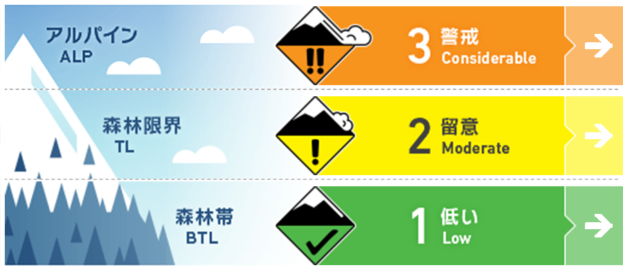
アルパイン Good ストームスラブと点発生乾雪雪崩は、特に沿岸区域の北部で観察されています。過去数日でさらに積雪が増えています。Storm slabs and loose dry activity will be found especially in the North of the range along the Sea of Japan coast where higher snow totals have accumulated over the previous few days.
森林限界 Good 急斜面では、点発生乾雪雪崩がありうる状態、ストームスラブは誘発の可能性がまだ残っています。Steep terrain will produce loose dry activity and the possibility of storm slab remains.
森林帯 Good 地形の罠に警戒し、適切な安全行動様式を使ってください。Manage your exposure to terrain traps and use proper safe travel techniques.
信頼度:○ good □ Fair △ Low
行動と地形の助言
標高の高いところでの観察情報が乏しいため、不確実性が高い状態です。多量降雪のあった直後、山に入る際は、現在のコンディション情報を十分に得るまでは、傾斜の緩いところ選んで行動することが賢明は方法です。最近、発生した真新しい雪崩がないかを探し、荒天の雪の中に弱い箇所がないかを探します。With little in the way of observations at higher elevations, there are a lot of unknowns at present. If heading into the backcountry in areas that have received a huge volume of new snow starting your day o lower angled terrain to gain knowledge on conditions would be wise. Look for signs of recent avalanche activity and check the latest new snow for weakness with the storm snow.
留意すべき雪崩
点発生乾雪雪崩 Dry Loose snow


大量降雪により、急峻な地形では点発生雪崩がおこりやすい状態といえます。このタイプの雪崩は、誘発した時点では小さくとも、長い急斜面であれば、流下する間に規模が大きくなりえます。With high volumes of new snow, we expect loose dry activity to occur in steep angled terrain. These avalanches can be started by a single person and grow in size as they build volume in their paths.
ストームスラブ Storm slab


日曜から100 cm以上の降雪がありました。このため、雪崩情報区域の北側エリアのアルパインでは、人的な刺激でのストームスラブの誘発がありえる状態です。With over 100cm of new snow accumulated between Sunday and now in the North of the range there is a possibility of Storm Slab activity to be triggered by the single-person load at higher elevations.
概要
雪崩
真新しい雪崩は報告されていません。観察データはForecaster teamに直接送付することが可能です。No new avalanche activity has been reported. You can contact the forecasting team with any observation at forecasters@nadare.jp
積雪
過去数日の降雪量は地域でバラツキがあります。日本海側の北側区域(余市岳など)では100 cm以上の降雪となっていますが、南側区域(尻別岳など)では40 cm程度となっています。フィールドでは、この新雪内にある不安定性を調べる必要があります。特に、西寄りの中程度の風が形成した軟らかいスラブに注意してください。There is a large variance in new snow totals over the previous few days. In the North of the range along the Sea of Japan Coast mountains like Mt Yoichi have reveived over 100cm of new snow whilst Shirebetsu in the South has received closer to 40cm. With so much new snow we ecxpect instabilties within the latedt new snow that will need to investigated. Moderate winds form the west may have produced soft slab in exposed areas and loose dry activity can be expected.
天候
日本海沿岸と札幌での大雪の後、その降雪は収まりを見せ始めています。週の後半には晴れが予報されており、風も弱いから中程度の西風とのことです。After heavy snowfall along the Sea of Japan coast and Sapporo coming to a standstill, it looks like the new snow totals will begin to taper with clear skies forecast later in the week. The winds will remain low to moderate from the West.


