
雪崩情報
更新日時: 2021/03/20 06:00
ニセコ・羊蹄・余市・尻別
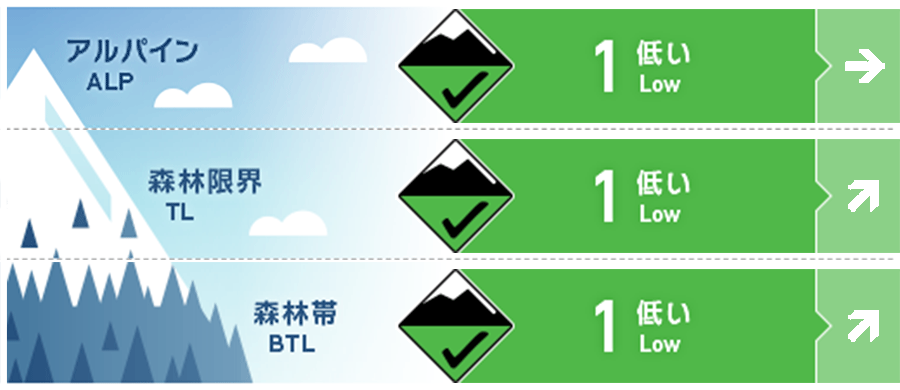
アルパイン Fair Potential for wet slide activity on Sunday if rain falls at high elevations 日曜日は標高の高いところまで雨が降る予報がでており、濡れた雪による雪崩に注意する必要があります。
森林限界 Fair Rain on Sunday may increase the danger rating with the possibility of wet slide activity in steep terrain. 日曜日は雨が降る予報がでており、急斜面では濡れた雪による雪崩の危険性が上昇します。
森林帯 Fair High temperatures and rainfall at lower elevation may rapidly change the snow surface conditions early in the day. 標高の低いところでは、高い気温と降雨によって、一日の早いうちから積雪状態が急激に悪化することに注意してください。
信頼度:○ good □ Fair △ Low
行動と地形の助言
Look for any signs of roller balling as temperatures increase in the middle part of the day. If rain does begin over the weekend be wary of rapid change in the surface conditions and avoid steep angled terrain above obvious terrain traps or grouping up below glide cracks. 日中の昇温に気づいたら、スノーボールが発生していないか周囲を観察してください。また、日曜日は、降雨の開始と共に、急な斜面の状態変化に注意し、既にグライドクラックの入った斜面や、地形の罠のある極端な地形の下に入り込まないようにしてください。
留意すべき雪崩
全層雪崩 Glide slab


With temperatures reaching above freezing and the likelihood of rain on Sunday be cautious of glide releases in the heat of the day or after prolonged rainfall. 日曜日には高い気温と降雨が予報されていますので、特に昇温している日中や長時間の降雨後には、全層雪崩に注意する必要があります。
点発生湿雪雪崩 Wet Loose snow


Freezing levels are due to rise over the weekend with the possibility of rainfall on Sunday. If this occurs be wary of wet loose activity in steep terrain. Look for any signs of roller balling early in the day that will suggest the surface conditions are becoming unstable. 今後、気温が上昇し、日曜日には降雨の予報が出ています。急斜面では降雨による積雪表層の強度が失われて発生する濡れた雪の雪崩に注意する必要があります。スノーボールの発生は、積雪表層の強度が低下していることの兆候となります。
概要
雪崩
No new avalanche activity has been reported in the previous 7 days. 過去7日間、真新しい雪崩の発生報告は入っていません。
積雪
After a period of settled weather without much in the way of new snowfall, the snowpack at lower elevations resembles typical spring conditions. Any overnight freeze makes way for softening during the day if temperatures and solar input alow. At higher elevations, the snow on Northerly aspects remains dry with up to 20cm of loose snow overlying a firm crust. 降雪のない安定した天候が続いたこともあり、標高の低い場所の積雪は、典型的な春のサイクルとなっています。夜間に凍結し、日中の昇温と日射で雪面は融解し、強度が下がります。一方、標高の高い場所の北側斜面では、まだ、雪はドライのままで、以前に形成したクラストの上に20cmほどの乾雪があります。
天候
A high-pressure system will make itself know early on Saturday bringing warm and sunny conditions in the early part of the weekend. As the high moves East it will be followed quickly by a low bringing rainfall to high elevations throughout Sunday. 土曜日には高気圧が張り出すことで、この週末の前半は暖かく、晴れる予報がでています。しかし、その後、高気圧が東へ移動すると、低気圧が接近するため、日曜には標高の高いところでも降雨となる予報です。


