
雪崩情報
更新日時: 2021/02/13 06:09
ニセコ・羊蹄・余市・尻別
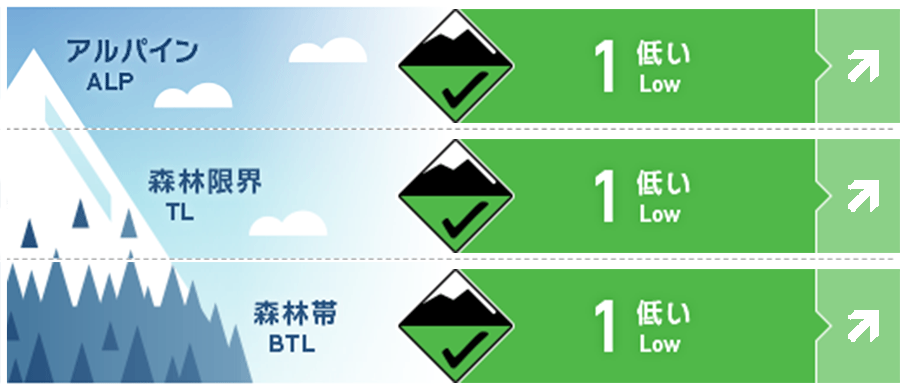
アルパイン Good Firm wind scoured and packed surface NW aspects. Small pockets old windslab with melt freeze crusts E-SE-S-SW-W . 北西斜面は、風で削剥あるはパックされています。東~南~西の斜面では、局所に形成した古いウインドスラブと融解凍結クラストの組み合わせとなっています。
森林限界 Good Melt freeze crusts solar aspects 日射を受ける斜面で融解凍結クラスト
森林帯 Good
信頼度:○ good □ Fair △ Low
行動と地形の助言
Avoid very steep solar facing aspects as the sun and air warm the snow rapidly. Loose wet slides could carry you into a terrain trap. Be careful on and around building roofs which could shed snow. Glide avalanche activity expected to increase as warm weather and rain is possible Monday. With the deep snowpack and recent warm weather watch out for opening glide cracks and avoid time on common glide avalanche paths. 日射の影響があるとても急な斜面を避けてください。昇温と日射の影響で、積雪は急激に弱くなり、濡れた雪によって「地形の罠」に流される可能性があります。建物からの落屑にも警戒を。今後の天気予報により、昇温と降雨が予報されていますので、全層雪崩の危険は継続します。積雪の多い場所では、最近の暖かい天気が与えた影響を考え、グライドクラックに気づくことや、それが既に形成されている雪崩地形を避けることが大切です。
留意すべき雪崩
点発生湿雪雪崩 Wet Loose snow


Watch out solar aspects on very steep slopes as day time temperatures rise and surface snow weakens. 日射の影響を受けるとても急な斜面では、気温の上昇に伴う積雪表層の雪の強度低下に注意してください。
全層雪崩 Glide slab


With continued warm daytime temperatures Sun and possible rain next week expect glide crack and release on known paths. 日中は暖かい日が続いており、日射もありました。この後、降雨も予報されており、既にグライドクラックが開いた斜面では全層雪崩の危険が高まります。
概要
雪崩
Glide avalanche reported west peak Shiribetsu yesterday on a Southwest aspect. Roof avalanches continue to be a problem. 昨日(2月12日)、尻別岳西峰の南西斜面で全層雪崩の発生が報告されています。屋根からの落雪が麓では問題となっています。
積雪
Freeze thaw conditions on solar aspects the last several days with significant settlement. On wind sheltered shaded slopes expect surface faceting and surface hoar. Lower snow pack mostly well bonded and gaining strength. Glide motion is opening cracks and expect to increase the next several days. 過去数日間の融解凍結のサイクルで、積雪はかなり沈降しました。風の影響がない斜面では、雪面の雪の再結晶化と表面霜の形成が疑われています。積雪下層は、十分な結合状態にあり、強度を増しています。グライドは進み、クラックも拡大していますので、今後、危険度の上昇に注意が必要です。
天候
Today High pressure brings another day of clear skies, light winds and warm air temperatures. Thin High clouds this early morning over northern forecast area are expected to clear out. Sunday SW flow brings cloudy conditions with rising freezing levels before Rain on Monday 今日は、高気圧の影響で晴天となり、風も弱く、気温が上昇する予報がでています。現在、北側のエリアでは高層に薄雲が出ていますが、晴れてくるとのことです。日曜日には、降雨が始まる前に、南西の風を伴いながら、くもりとなる予報がでています。