
雪崩情報
更新日時: 2022/01/13 07:00
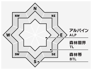
ニセコ・羊蹄・余市・尻別
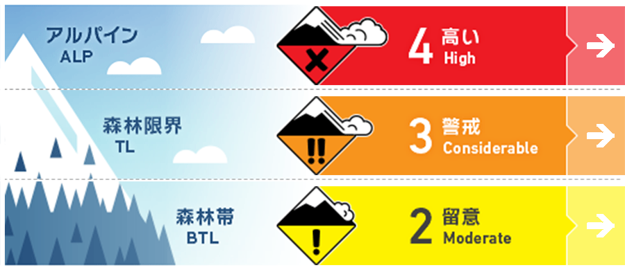
アルパイン Fair ストームスラブがいろいろな面で形成しており、小さい刺激にも反応する状態です。アルパインエリアの急斜面は、現時点では避けることが賢明です。Storm slabs will have formed on multiple aspects and are likely to be reactive to light loads. Steep angled terrain in the Alpine should be avoided at present.
森林限界 Fair 直近の降雪は不安定であるため、ルートファインディングは複雑です。急斜面を避け、樹林内にある危険度の高い場所や、地形の罠に気をつけてください。Instability within the latest new snow will make route selection complex at present. Avoid steep terrain and be wary of high consequence areas and terrain traps in the tree line.
森林帯 Good 新雪内にある脆弱性を探しつつ、重大な結末をもたらす地形に警戒を。Be wary of obvious features with high consequences as we look for weakness within this latest new snow.
信頼度:○ good □ Fair △ Low
行動と地形の助言
今回の荒天によって、地形移動のルート設定は難度が高くなっていますので、今後48時間は重大な結末をもたらす地形は避けるようにしてください。真新しい雪崩の発生跡がないか、雪庇が崩落していないか、シューティングクラックはあるかなど、不安定性の明瞭な兆候を見逃さないように。標高の低いところえは、河岸段丘の側面のような地形の罠となる急斜面に特に注意が必要です。It will be wise to avoid consequential terrain for the next 48 hours as this latest storm will have created complex terrain travel. Take the time to properly look for obvious signs of instability such as recent avalanche activity, cornice failure, and cracking. At lower elevations be wary of micro features above terrain traps such as steeply angled river beds.
留意すべき雪崩
ストームスラブ Storm slab


多量の降雪があり、強いあるいは暴風が吹いています。気温や風向風速の変化によって、新雪には不安定性が生じており、多様な方位、あるいは標高の高い場所では、小さい負荷(人の刺激程度)で反応する状態です。今回の荒天の期間で、雪崩サイクルがあったと考えるのが自然で、この新しいスラブが落ち着くまで、小さい負荷で反応すると考えてください。We have received a large amount of new snow across the region combined with gale to extreme winds. Changes in both temperature, wind direction, and wind speed during this latest storm have produced instabilities within the new snow that is expected to be reactive to light loads across multiple aspects and elevations. A natural cycle of avalanche activity is likely to have occurred during this storm period and the new slab formation will be reactive to light loads until it has time to settle.
概要
雪崩
過去数日、荒天もあり、新しい雪崩の報告はありません。No new activity has been reported in the previous few days.
積雪
この荒天が訪れる前、積雪は全体的には強度を増しており、積雪の中層まではしっかりと強度を上げているようでした。現在、地域全体で50 cmをはるかに超える新雪が降り、北西の暴風も加わっています。さらなる観察が必要ですが、複数の方位と標高で、反応しやすいスラブの形成が強く疑われています。Previous to this latest weather event the overall snowpack had gained strength and appeared to be well bonded through the mid-pack. We have now received well in excess of 50cm of new snow across the region combined with gale to extreme North West winds. Although further observations need to occur we expect reactive slab formation across multiple aspects and elevations.
天候
本日は降雪と強風が継続する予報が出ています。今回の荒天は、週末には落ち着きをみせるとのことです。Continued snowfall and gale to extreme winds are expected to continue into Thursday. The storm system that has dominated the midweek will begin to move North by the weekend bringing more settled weather.